Conteville, Seine-Maritime
| Conteville | |
|---|---|
| Commune | |
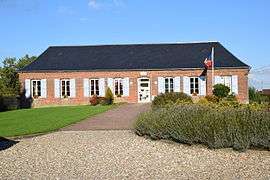 The town hall in Conteville | |
 Conteville Location within Normandy region  Conteville | |
| Coordinates: 49°41′42″N 1°38′06″E / 49.695°N 1.635°ECoordinates: 49°41′42″N 1°38′06″E / 49.695°N 1.635°E | |
| Country | France |
| Region | Normandy |
| Department | Seine-Maritime |
| Arrondissement | Dieppe |
| Canton | Gournay-en-Bray |
| Intercommunality | CC Aumale - Blangy-sur-Bresle |
| Government | |
| • Mayor (2008–2014) | Yolaine Féron |
| Area1 | 13.71 km2 (5.29 sq mi) |
| Population (2006)2 | 477 |
| • Density | 35/km2 (90/sq mi) |
| Time zone | UTC+1 (CET) |
| • Summer (DST) | UTC+2 (CEST) |
| INSEE/Postal code | 76186 /76390 |
| Elevation |
193–247 m (633–810 ft) (avg. 248 m or 814 ft) |
|
1 French Land Register data, which excludes lakes, ponds, glaciers > 1 km2 (0.386 sq mi or 247 acres) and river estuaries. 2 Population without double counting: residents of multiple communes (e.g., students and military personnel) only counted once. | |
Conteville is a commune in the Seine-Maritime department in the Normandy region in northern France.
Geography
A farming village situated in the Pays de Bray, some 36 miles (58 km) southeast of Dieppe, at the junction of the D9 and the D36 roads.
Population
| Year | 1962 | 1968 | 1975 | 1982 | 1990 | 1999 | 2006 |
|---|---|---|---|---|---|---|---|
| Population | 465 | 504 | 447 | 401 | 460 | 454 | 477 |
| From the year 1962 on: No double counting—residents of multiple communes (e.g. students and military personnel) are counted only once. | |||||||
Places of interest
- The church of St.Nicolas, dating from the eighteenth century.
See also
References
External links
| Wikimedia Commons has media related to Conteville (Seine-Maritime). |
- Conteville on the Quid website (in French)
This article is issued from
Wikipedia.
The text is licensed under Creative Commons - Attribution - Sharealike.
Additional terms may apply for the media files.