Thiouville
| Thiouville | ||
|---|---|---|
| Commune | ||
 The town hall in Thiouville | ||
| ||
 Thiouville Location within Normandy region  Thiouville | ||
| Coordinates: 49°41′40″N 0°37′11″E / 49.6944°N 0.6197°ECoordinates: 49°41′40″N 0°37′11″E / 49.6944°N 0.6197°E | ||
| Country | France | |
| Region | Normandy | |
| Department | Seine-Maritime | |
| Arrondissement | Dieppe | |
| Canton | Saint-Valery-en-Caux | |
| Intercommunality | CC Côte d'Albâtre | |
| Government | ||
| • Mayor | Isabelle Dujardin | |
| Area1 | 5.86 km2 (2.26 sq mi) | |
| Population (2006)2 | 284 | |
| • Density | 48/km2 (130/sq mi) | |
| Time zone | UTC+1 (CET) | |
| • Summer (DST) | UTC+2 (CEST) | |
| INSEE/Postal code | 76692 /76450 | |
| Elevation |
114–140 m (374–459 ft) (avg. 110 m or 360 ft) | |
|
1 French Land Register data, which excludes lakes, ponds, glaciers > 1 km2 (0.386 sq mi or 247 acres) and river estuaries. 2 Population without double counting: residents of multiple communes (e.g., students and military personnel) only counted once. | ||
.svg.png)
Thiouville is a commune in the Seine-Maritime department in the Normandy region in northern France.
Geography
A farming village in the Pays de Caux, situated some 27 miles (43 km) northeast of Le Havre, at the junction of the D233 and D109 roads.
Population
| 1962 | 1968 | 1975 | 1982 | 1990 | 1999 | 2006 |
|---|---|---|---|---|---|---|
| 258 | 271 | 257 | 242 | 235 | 240 | 284 |
| Starting in 1962: Population without duplicates | ||||||
Places of interest
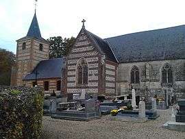
- The church of St. Vaast, dating from the sixteenth century.
- An eighteenth-century chateau.
See also
References
External links
| Wikimedia Commons has media related to Thiouville. |
- Thiouville on the Quid website (in French)
This article is issued from
Wikipedia.
The text is licensed under Creative Commons - Attribution - Sharealike.
Additional terms may apply for the media files.