La Haye, Seine-Maritime
| La Haye | |
|---|---|
| Commune | |
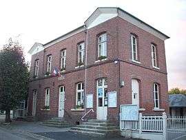 The town hall in La Haye | |
 La Haye Location within Normandy region  La Haye | |
| Coordinates: 49°28′00″N 1°26′33″E / 49.4667°N 1.4425°ECoordinates: 49°28′00″N 1°26′33″E / 49.4667°N 1.4425°E | |
| Country | France |
| Region | Normandy |
| Department | Seine-Maritime |
| Arrondissement | Dieppe |
| Canton | Gournay-en-Bray |
| Intercommunality | CC 4 rivières |
| Government | |
| • Mayor | François Bigot |
| Area1 | 6.74 km2 (2.60 sq mi) |
| Population (2006)2 | 254 |
| • Density | 38/km2 (98/sq mi) |
| Time zone | UTC+1 (CET) |
| • Summer (DST) | UTC+2 (CEST) |
| INSEE/Postal code | 76352 /76780 |
| Elevation |
75–177 m (246–581 ft) (avg. 174 m or 571 ft) |
|
1 French Land Register data, which excludes lakes, ponds, glaciers > 1 km2 (0.386 sq mi or 247 acres) and river estuaries. 2 Population without double counting: residents of multiple communes (e.g., students and military personnel) only counted once. | |
La Haye is a commune in the Seine-Maritime department in the Normandy region in northern France.
Geography
A forestry and farming village situated by the banks of the Andelle river in the Pays de Bray, some 17 miles (27 km) east of Rouen at the junction of the N31 and the D413 roads.
Population
| Year | 1962 | 1968 | 1975 | 1982 | 1990 | 1999 | 2006 |
|---|---|---|---|---|---|---|---|
| Population | 180 | 213 | 204 | 222 | 218 | 263 | 266 |
| From the year 1962 on: No double counting—residents of multiple communes (e.g. students and military personnel) are counted only once. | |||||||
Places of interest
- The church of St.Peter & St.Paul, dating from the twelfth century.
See also
References
External links
| Wikimedia Commons has media related to La Haye (Seine-Maritime). |
- La Haye on the Quid website (in French)
This article is issued from
Wikipedia.
The text is licensed under Creative Commons - Attribution - Sharealike.
Additional terms may apply for the media files.