Pierrefiques
| Pierrefiques | ||
|---|---|---|
| Commune | ||
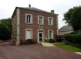 The town hall in Pierrefiques | ||
| ||
 Pierrefiques Location within Normandy region  Pierrefiques | ||
| Coordinates: 49°40′18″N 0°13′59″E / 49.6717°N 0.2331°ECoordinates: 49°40′18″N 0°13′59″E / 49.6717°N 0.2331°E | ||
| Country | France | |
| Region | Normandy | |
| Department | Seine-Maritime | |
| Arrondissement | Le Havre | |
| Canton | Octeville-sur-Mer | |
| Intercommunality | CC Canton de Criquetot-l'Esneval | |
| Area1 | 2.31 km2 (0.89 sq mi) | |
| Population (2006)2 | 122 | |
| • Density | 53/km2 (140/sq mi) | |
| Time zone | UTC+1 (CET) | |
| • Summer (DST) | UTC+2 (CEST) | |
| INSEE/Postal code | 76501 /76280 | |
| Elevation |
15–107 m (49–351 ft) (avg. 90 m or 300 ft) | |
|
1 French Land Register data, which excludes lakes, ponds, glaciers > 1 km2 (0.386 sq mi or 247 acres) and river estuaries. 2 Population without double counting: residents of multiple communes (e.g., students and military personnel) only counted once. | ||
.svg.png)
Pierrefiques is a commune in the Seine-Maritime department in the Normandy region in northern France.
Geography
A small farming village in the Pays de Caux, situated some 15 miles (24 km) northeast of Le Havre, just off the D139 road.
Population
| 1962 | 1968 | 1975 | 1982 | 1990 | 1999 | 2006 |
|---|---|---|---|---|---|---|
| 72 | 91 | 79 | 85 | 97 | 106 | 122 |
| Starting in 1962: Population without duplicates | ||||||
Places of interest
- The church of St. Jean-Baptiste, dating from the sixteenth century.
See also
References
External links
| Wikimedia Commons has media related to Pierrefiques. |
- Pierrefiques on the Quid website (in French)
This article is issued from
Wikipedia.
The text is licensed under Creative Commons - Attribution - Sharealike.
Additional terms may apply for the media files.