Avremesnil
| Avremesnil | ||
|---|---|---|
| Commune | ||
.jpg) The town hall in Avremesnil | ||
| ||
 Avremesnil Location within Normandy region  Avremesnil | ||
| Coordinates: 49°51′02″N 0°55′40″E / 49.8506°N 0.9278°ECoordinates: 49°51′02″N 0°55′40″E / 49.8506°N 0.9278°E | ||
| Country | France | |
| Region | Normandy | |
| Department | Seine-Maritime | |
| Arrondissement | Dieppe | |
| Canton | Luneray | |
| Intercommunality | CC Terroir Caux | |
| Government | ||
| • Mayor (2014-2020) | Jean-Michel Déparois | |
| Area1 | 5.42 km2 (2.09 sq mi) | |
| Population (2014)2 | 1,024 | |
| • Density | 190/km2 (490/sq mi) | |
| Time zone | UTC+1 (CET) | |
| • Summer (DST) | UTC+2 (CEST) | |
| INSEE/Postal code | 76050 /76730 | |
| Elevation |
11–82 m (36–269 ft) (avg. 90 m or 300 ft) | |
|
1 French Land Register data, which excludes lakes, ponds, glaciers > 1 km2 (0.386 sq mi or 247 acres) and river estuaries. 2 Population without double counting: residents of multiple communes (e.g., students and military personnel) only counted once. | ||
Avremesnil is a commune in the Seine-Maritime department in the Normandy region in northern France.
Geography
A farming village in the valley of the Saâne river, in the Pays de Caux, situated some 8 miles (13 km) southwest of Dieppe, at the junction of the D27 and D2 roads.
Heraldry
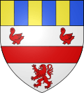 |
The arms of Avremesnil are blazoned : Argent, a fess between 2 martlets and a lion gules, and a chief paly Or and azure. |
Population
| Year | 1962 | 1968 | 1975 | 1982 | 1990 | 1999 | 2006 | 2014 |
|---|---|---|---|---|---|---|---|---|
| Population | 700 | 798 | 839 | 832 | 878 | 873 | 934 | 1024 |
| From the year 1962 on: No double counting—residents of multiple communes (e.g. students and military personnel) are counted only once. | ||||||||
Places of interest
- The church of St.Aubin, dating from the twelfth century.
- The sixteenth century manorhouse.
- The motte and other vestiges of the medieval chateau.
See also
References
External links
| Wikimedia Commons has media related to Avremesnil. |
- The official website of the commune (in French)
- Avremesnil on the Quid website (in French)
This article is issued from
Wikipedia.
The text is licensed under Creative Commons - Attribution - Sharealike.
Additional terms may apply for the media files.