Baons-le-Comte
| Baons-le-Comte | ||
|---|---|---|
| Commune | ||
| ||
 Baons-le-Comte Location within Normandy region  Baons-le-Comte | ||
| Coordinates: 49°38′33″N 0°46′39″E / 49.6425°N 0.7775°ECoordinates: 49°38′33″N 0°46′39″E / 49.6425°N 0.7775°E | ||
| Country | France | |
| Region | Normandy | |
| Department | Seine-Maritime | |
| Arrondissement | Rouen | |
| Canton | Yvetot | |
| Government | ||
| • Mayor | Marie-Josèphe Carpentier | |
| Area1 | 5.38 km2 (2.08 sq mi) | |
| Population (2006)2 | 345 | |
| • Density | 64/km2 (170/sq mi) | |
| Time zone | UTC+1 (CET) | |
| • Summer (DST) | UTC+2 (CEST) | |
| INSEE/Postal code | 76055 /76190 | |
| Elevation |
131–154 m (430–505 ft) (avg. 170 m or 560 ft) | |
|
1 French Land Register data, which excludes lakes, ponds, glaciers > 1 km2 (0.386 sq mi or 247 acres) and river estuaries. 2 Population without double counting: residents of multiple communes (e.g., students and military personnel) only counted once. | ||
Baons-le-Comte is a commune in the Seine-Maritime department in the Normandy region in northern France.
Geography
A farming village situated in the Pays de Caux, some 22 miles (35 km) northwest of Rouen at the junction of the D240, D37 and the D55 roads. The A29 autoroute joins with the A150 autoroute within the commune’s territory.
Heraldry
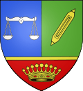 |
The arms of Baons-le-Comte are blazoned : Per pale azure and vert, a balance argent and a (weaver's) shuttle bendwise sinister Or, and on a base gules fimbriated Or a jeweled county coronet proper. |
Population
| Year | 1962 | 1968 | 1975 | 1982 | 1990 | 1999 | 2006 |
|---|---|---|---|---|---|---|---|
| Population | 225 | 247 | 289 | 303 | 340 | 359 | 345 |
| From the year 1962 on: No double counting—residents of multiple communes (e.g. students and military personnel) are counted only once. | |||||||
Places of interest
- The chateau, dating from the nineteenth century.
- The church of St.Romain, dating from the twelfth century.
See also
References
External links
| Wikimedia Commons has media related to Baons-le-Comte. |
- Baons-le-Comte on the Quid website (in French)
This article is issued from
Wikipedia.
The text is licensed under Creative Commons - Attribution - Sharealike.
Additional terms may apply for the media files.