Louvetot
| Louvetot | ||
|---|---|---|
| Commune | ||
| ||
 Louvetot Location within Normandy region  Louvetot | ||
| Coordinates: 49°34′21″N 0°42′50″E / 49.5725°N 0.7139°ECoordinates: 49°34′21″N 0°42′50″E / 49.5725°N 0.7139°E | ||
| Country | France | |
| Region | Normandy | |
| Department | Seine-Maritime | |
| Arrondissement | Rouen | |
| Canton | Notre-Dame-de-Gravenchon | |
| Intercommunality | CA Caux vallée de Seine | |
| Government | ||
| • Mayor (2001–2008) | Alain Legrand | |
| Area1 | 7.37 km2 (2.85 sq mi) | |
| Population (2006)2 | 701 | |
| • Density | 95/km2 (250/sq mi) | |
| Time zone | UTC+1 (CET) | |
| • Summer (DST) | UTC+2 (CEST) | |
| INSEE/Postal code | 76398 /76490 | |
| Elevation |
37–152 m (121–499 ft) (avg. 140 m or 460 ft) | |
|
1 French Land Register data, which excludes lakes, ponds, glaciers > 1 km2 (0.386 sq mi or 247 acres) and river estuaries. 2 Population without double counting: residents of multiple communes (e.g., students and military personnel) only counted once. | ||
Louvetot is a commune in the Seine-Maritime department in the Normandy region in northern France.
Geography
A farming village situated in the Pays de Caux, some 20 miles (32 km) northwest of Rouen, at the junction of the D33 and the D131 roads.
Heraldry
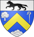 |
The arms of Louvetot are blazoned : Azure, a chevron Or between an oaktree, an abbot's crozier and a barrow, and on a chief argent a wolf passant sable. |
Population
| 1962 | 1968 | 1975 | 1982 | 1990 | 1999 | 2006 |
|---|---|---|---|---|---|---|
| 382 | 417 | 439 | 500 | 562 | 575 | 701 |
| Starting in 1962: Population without duplicates | ||||||
Places of interest
- The church of Notre-Dame, dating from the thirteenth century.
- An old manorhouse.
See also
References
External links
| Wikimedia Commons has media related to Louvetot. |
- Louvetot on the Quid website (in French)
This article is issued from
Wikipedia.
The text is licensed under Creative Commons - Attribution - Sharealike.
Additional terms may apply for the media files.