La Remuée
| La Remuée | ||
|---|---|---|
| Commune | ||
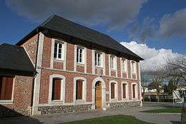 The town hall in La Remuée | ||
| ||
 La Remuée Location within Normandy region  La Remuée | ||
| Coordinates: 49°31′43″N 0°24′15″E / 49.5286°N 0.4042°ECoordinates: 49°31′43″N 0°24′15″E / 49.5286°N 0.4042°E | ||
| Country | France | |
| Region | Normandy | |
| Department | Seine-Maritime | |
| Arrondissement | Le Havre | |
| Canton | Saint-Romain-de-Colbosc | |
| Government | ||
| • Mayor | Olivier Haas | |
| Area1 | 7.03 km2 (2.71 sq mi) | |
| Population (2006)2 | 1,323 | |
| • Density | 190/km2 (490/sq mi) | |
| Time zone | UTC+1 (CET) | |
| • Summer (DST) | UTC+2 (CEST) | |
| INSEE/Postal code | 76522 /76430 | |
| Elevation |
103–135 m (338–443 ft) (avg. 129 m or 423 ft) | |
|
1 French Land Register data, which excludes lakes, ponds, glaciers > 1 km2 (0.386 sq mi or 247 acres) and river estuaries. 2 Population without double counting: residents of multiple communes (e.g., students and military personnel) only counted once. | ||
La Remuée is a commune in the Seine-Maritime department in the Normandy region in northern France.
Geography
A farming village in the Pays de Caux, some 10 miles (16 km) east of Le Havre, at the junction of the D112 and D81 roads.
Heraldry
 |
The arms of La Remuée are blazoned : Gules, 2 swords in saltire argent between 4 martlets Or. |
Population
| Year | 1962 | 1968 | 1975 | 1982 | 1990 | 1999 | 2006 |
|---|---|---|---|---|---|---|---|
| Population | 449 | 484 | 640 | 711 | 861 | 1176 | 1323 |
| From the year 1962 on: No double counting—residents of multiple communes (e.g. students and military personnel) are counted only once. | |||||||
Places of interest
- The church of St. Thomas, dating from the nineteenth century.
- Notre-Dame church, dating from the thirteenth century.
- The chateau de Marefosse.
See also
References
External links
| Wikimedia Commons has media related to La Remuée. |
- Official website of the commune (in French)
- Printemps de La Remuée road run, the premier race in the département (in French)
- La Remuée on the Quid website (in French)
This article is issued from
Wikipedia.
The text is licensed under Creative Commons - Attribution - Sharealike.
Additional terms may apply for the media files.