Saint-Antoine-la-Forêt
| Saint-Antoine-la-Forêt | ||
|---|---|---|
| Commune | ||
 The town hall in Saint-Antoine-la-Forêt | ||
| ||
 Saint-Antoine-la-Forêt Location within Normandy region  Saint-Antoine-la-Forêt | ||
| Coordinates: 49°32′17″N 0°28′21″E / 49.5381°N 0.4725°ECoordinates: 49°32′17″N 0°28′21″E / 49.5381°N 0.4725°E | ||
| Country | France | |
| Region | Normandy | |
| Department | Seine-Maritime | |
| Arrondissement | Le Havre | |
| Canton | Bolbec | |
| Intercommunality | CA Caux vallée de Seine | |
| Area1 | 6.44 km2 (2.49 sq mi) | |
| Population (2006)2 | 1,004 | |
| • Density | 160/km2 (400/sq mi) | |
| Time zone | UTC+1 (CET) | |
| • Summer (DST) | UTC+2 (CEST) | |
| INSEE/Postal code | 76556 /76170 | |
| Elevation |
10–137 m (33–449 ft) (avg. 135 m or 443 ft) | |
|
1 French Land Register data, which excludes lakes, ponds, glaciers > 1 km2 (0.386 sq mi or 247 acres) and river estuaries. 2 Population without double counting: residents of multiple communes (e.g., students and military personnel) only counted once. | ||
Saint-Antoine-la-Forêt is a commune in the Seine-Maritime department in the Normandy region in northern France.
Geography
A farming village in the Pays de Caux, situated some 18 miles (29 km) east of Le Havre, at the junction of the D34 and D17 roads, in the valley of the Bolbec river.
Heraldry
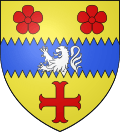 |
The arms of Saint-Antoine-la-Forêt are blazoned : Or, on a fess indented azure between 2 angennes and a cross moline gules, a demi-lion issuant from the base of the fess argent.[1] |
Population
| 1962 | 1968 | 1975 | 1982 | 1990 | 1999 | 2006 |
|---|---|---|---|---|---|---|
| 489 | 515 | 530 | 749 | 902 | 935 | 1004 |
| Starting in 1962: Population without duplicates | ||||||
Places of interest
- The church of St. Antoine, dating from the twelfth century.
- The manorhouse at Les Côtières.
See also
References
- ↑ (Note: this angenne is very rose-like, not the highly stylized cinqfoil.)
External links
| Wikimedia Commons has media related to Saint-Antoine-la-Forêt. |
- Saint-Antoine-la-Forêt on the Quid website (in French)
This article is issued from
Wikipedia.
The text is licensed under Creative Commons - Attribution - Sharealike.
Additional terms may apply for the media files.