Bennetot
| Bennetot | ||
|---|---|---|
| ||
 Bennetot Location within Normandy region  Bennetot | ||
| Coordinates: 49°40′19″N 0°33′11″E / 49.6719°N 0.5531°ECoordinates: 49°40′19″N 0°33′11″E / 49.6719°N 0.5531°E | ||
| Country | France | |
| Region | Normandy | |
| Department | Seine-Maritime | |
| Arrondissement | Le Havre | |
| Canton | Saint-Valery-en-Caux | |
| Area1 | 4.58 km2 (1.77 sq mi) | |
| Population (2006)2 | 171 | |
| • Density | 37/km2 (97/sq mi) | |
| Time zone | UTC+1 (CET) | |
| • Summer (DST) | UTC+2 (CEST) | |
| INSEE/Postal code | 76078 /76640 | |
| Elevation |
97–131 m (318–430 ft) (avg. 121 m or 397 ft) | |
|
1 French Land Register data, which excludes lakes, ponds, glaciers > 1 km2 (0.386 sq mi or 247 acres) and river estuaries. 2 Population without double counting: residents of multiple communes (e.g., students and military personnel) only counted once. | ||
Bennetot is a former commune in the Seine-Maritime department in the Normandy region in northern France. On 1 January 2017, it was merged into the new commune Terres-de-Caux.[1]
Geography
A small farming village situated in the Pays de Caux, some 22 miles (35 km) northeast of Le Havre, at the junction of the D926 and the D217.
Heraldry
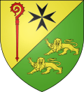 |
The arms of Bennetot are blazoned : Per bend sinister, 1: Or, an abbot's crozier gules, and to sinister a maltese cross sable; 2: vert, 2 leopards Or |
Population
| Year | 1962 | 1968 | 1975 | 1982 | 1990 | 1999 | 2006 |
|---|---|---|---|---|---|---|---|
| Population | 143 | 148 | 105 | 113 | 97 | 127 | 171 |
| From the year 1962 on: No double counting—residents of multiple communes (e.g. students and military personnel) are counted only once. | |||||||
Places of interest
- The church of St.André, dating from the seventeenth century.
- A sixteenth century manorhouse
Notable people
- Réné-Aubert Vertot, French historian, was born here on the 25th Nov 1655.
See also
References
- ↑ Arrêté préfectoral 12 September 2016 (in French)
External links
| Wikimedia Commons has media related to Bennetot. |
- Bennetot on the Quid website (in French)
This article is issued from
Wikipedia.
The text is licensed under Creative Commons - Attribution - Sharealike.
Additional terms may apply for the media files.