Limpiville
| Limpiville | |
|---|---|
| Commune | |
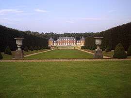 The chateau of Vaudroc | |
 Limpiville Location within Normandy region  Limpiville | |
| Coordinates: 49°41′26″N 0°30′13″E / 49.6906°N 0.5036°ECoordinates: 49°41′26″N 0°30′13″E / 49.6906°N 0.5036°E | |
| Country | France |
| Region | Normandy |
| Department | Seine-Maritime |
| Arrondissement | Le Havre |
| Canton | Fécamp |
| Intercommunality | CA Fécamp Caux Littoral |
| Area1 | 4.24 km2 (1.64 sq mi) |
| Population (2006)2 | 356 |
| • Density | 84/km2 (220/sq mi) |
| Time zone | UTC+1 (CET) |
| • Summer (DST) | UTC+2 (CEST) |
| INSEE/Postal code | 76386 /76540 |
| Elevation |
70–131 m (230–430 ft) (avg. 120 m or 390 ft) |
|
1 French Land Register data, which excludes lakes, ponds, glaciers > 1 km2 (0.386 sq mi or 247 acres) and river estuaries. 2 Population without double counting: residents of multiple communes (e.g., students and military personnel) only counted once. | |
Limpiville is a commune in the Seine-Maritime department in the Normandy region in northern France.
Geography
A farming village in the Pays de Caux situated some 24 miles (39 km) northeast of Le Havre, between the D17 and D28 roads.
Population
| 1962 | 1968 | 1975 | 1982 | 1990 | 1999 | 2006 |
|---|---|---|---|---|---|---|
| 315 | 324 | 280 | 276 | 283 | 340 | 356 |
| Starting in 1962: Population without duplicates | ||||||
Places of interest
- The church of Notre-Dame, dating from the eighteenth century.
- The seventeenth century Château du Vaudroc.
See also
References
External links
| Wikimedia Commons has media related to Limpiville. |
- Limpiville on the Quid website (in French)
This article is issued from
Wikipedia.
The text is licensed under Creative Commons - Attribution - Sharealike.
Additional terms may apply for the media files.