Saint-Aubin-sur-Mer, Seine-Maritime
| Saint-Aubin-sur-Mer | ||
|---|---|---|
| Commune | ||
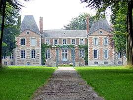 The chateau in Saint-Aubin-sur-Mer | ||
| ||
 Saint-Aubin-sur-Mer Location within Normandy region  Saint-Aubin-sur-Mer | ||
| Coordinates: 49°53′24″N 0°52′32″E / 49.89°N 0.8756°ECoordinates: 49°53′24″N 0°52′32″E / 49.89°N 0.8756°E | ||
| Country | France | |
| Region | Normandy | |
| Department | Seine-Maritime | |
| Arrondissement | Dieppe | |
| Canton | Saint-Valery-en-Caux | |
| Intercommunality | CC Côte d'Albâtre | |
| Government | ||
| • Mayor | France Petit | |
| Area1 | 6.21 km2 (2.40 sq mi) | |
| Population (2006)2 | 272 | |
| • Density | 44/km2 (110/sq mi) | |
| Time zone | UTC+1 (CET) | |
| • Summer (DST) | UTC+2 (CEST) | |
| INSEE/Postal code | 76564 /76740 | |
| Elevation |
0–54 m (0–177 ft) (avg. 20 m or 66 ft) | |
|
1 French Land Register data, which excludes lakes, ponds, glaciers > 1 km2 (0.386 sq mi or 247 acres) and river estuaries. 2 Population without double counting: residents of multiple communes (e.g., students and military personnel) only counted once. | ||
.svg.png)
Saint-Aubin-sur-Mer is a commune in the Seine-Maritime department in the Normandy region in northern France.
Geography
A village of farming and tourism situated in the Pays de Caux, at the junction of the D75, D68 and the D237 roads, some 13 miles (21 km) southwest of Dieppe. Here, huge chalk cliffs overlook a pebble beach and the English Channel.
Population
| 1962 | 1968 | 1975 | 1982 | 1990 | 1999 | 2006 |
|---|---|---|---|---|---|---|
| 258 | 264 | 235 | 280 | 281 | 280 | 272 |
| Starting in 1962: Population without duplicates | ||||||
Places of interest
- A Louis XIII style château, built on the old castle, with a dovecote and park.
- A seventeenth-century fortified manorhouse.
- Vestiges of the Atlantic Wall.
- The church of St. Aubin, dating from the twelfth century.
See also
References
External links
| Wikimedia Commons has media related to Saint-Aubin-sur-Mer (Seine-Maritime). |
- Saint-Aubin-sur-Mer on the Quid website (in French)
- Saint-Aubin-sur-Mer Official website (in French)
This article is issued from
Wikipedia.
The text is licensed under Creative Commons - Attribution - Sharealike.
Additional terms may apply for the media files.