Bois-Himont
| Bois-Himont | ||
|---|---|---|
| Commune | ||
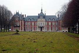 The chateau in Bois-Himont | ||
| ||
 Bois-Himont Location within Normandy region  Bois-Himont | ||
| Coordinates: 49°35′08″N 0°42′10″E / 49.5856°N 0.7028°ECoordinates: 49°35′08″N 0°42′10″E / 49.5856°N 0.7028°E | ||
| Country | France | |
| Region | Normandy | |
| Department | Seine-Maritime | |
| Arrondissement | Rouen | |
| Canton | Yvetot | |
| Government | ||
| • Mayor | Louis Dodelin | |
| Area1 | 5.84 km2 (2.25 sq mi) | |
| Population (2006)2 | 434 | |
| • Density | 74/km2 (190/sq mi) | |
| Time zone | UTC+1 (CET) | |
| • Summer (DST) | UTC+2 (CEST) | |
| INSEE/Postal code | 76110 /76190 | |
| Elevation |
65–150 m (213–492 ft) (avg. 140 m or 460 ft) | |
|
1 French Land Register data, which excludes lakes, ponds, glaciers > 1 km2 (0.386 sq mi or 247 acres) and river estuaries. 2 Population without double counting: residents of multiple communes (e.g., students and military personnel) only counted once. | ||
.svg.png)
Bois-Himont is a commune in the Seine-Maritime department in the Normandy region in northern France.
Geography
A farming village situated in the Pays de Caux, some 28 miles (45 km) northwest of Rouen at the junction of the D104 and the D33 roads.
Population
| Year | 1962 | 1968 | 1975 | 1982 | 1990 | 1999 | 2006 |
|---|---|---|---|---|---|---|---|
| Population | 181 | 193 | 182 | 312 | 334 | 392 | 434 |
| From the year 1962 on: No double counting—residents of multiple communes (e.g. students and military personnel) are counted only once. | |||||||
Places of interest
- The church of St.Laurent, dating from the thirteenth century.
- A fifteenth-century chapel.
- The eighteenth-century chateau, nowadays a hotel and conference centre.
See also
References
External links
| Wikimedia Commons has media related to Bois-Himont. |
- The Chateau de Bois-Himont (in French)
- Bois-Himont on the Quid website (in French)
This article is issued from
Wikipedia.
The text is licensed under Creative Commons - Attribution - Sharealike.
Additional terms may apply for the media files.