Rolleville
| Rolleville | ||
|---|---|---|
| Commune | ||
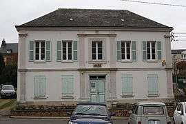 The town hall in Rolleville | ||
| ||
 Rolleville Location within Normandy region  Rolleville | ||
| Coordinates: 49°35′00″N 0°12′43″E / 49.5833°N 0.2119°ECoordinates: 49°35′00″N 0°12′43″E / 49.5833°N 0.2119°E | ||
| Country | France | |
| Region | Normandy | |
| Department | Seine-Maritime | |
| Arrondissement | Le Havre | |
| Canton | Octeville-sur-Mer | |
| Intercommunality | CA havraise | |
| Government | ||
| • Mayor (2001–2007) | Maryvonne Lebas | |
| Area1 | 7.06 km2 (2.73 sq mi) | |
| Population (2006)2 | 1,152 | |
| • Density | 160/km2 (420/sq mi) | |
| Time zone | UTC+1 (CET) | |
| • Summer (DST) | UTC+2 (CEST) | |
| INSEE/Postal code | 76534 /76133 | |
| Elevation |
27–107 m (89–351 ft) (avg. 45 m or 148 ft) | |
|
1 French Land Register data, which excludes lakes, ponds, glaciers > 1 km2 (0.386 sq mi or 247 acres) and river estuaries. 2 Population without double counting: residents of multiple communes (e.g., students and military personnel) only counted once. | ||
Rolleville is a commune in the Seine-Maritime department in the Normandy region in northern France.
Geography
A farming village with some light industry, by the banks of the Lézarde river in the Pays de Caux, situated some 10 miles (16 km) northeast of Le Havre, on the D32 road. SNCF has a TER railway station here.
Heraldry
 |
The arms of Rolleville are blazoned : Vert, on a bend sinister wavy between a dovecot argent and a garb of flax Or, 3 millwheels gules. |
Population
| 1962 | 1968 | 1975 | 1982 | 1990 | 1999 | 2006 |
|---|---|---|---|---|---|---|
| 908 | 910 | 873 | 1022 | 1081 | 1131 | 1152 |
| Starting in 1962: Population without duplicates | ||||||
Places of interest
- The nineteenth-century church of St. Hilaire.
- A sixteenth-century manorhouse.
See also
References
External links
| Wikimedia Commons has media related to Rolleville. |
- An unofficial website about Rolleville (in French)
- Rolleville on the Quid website (in French)
This article is issued from
Wikipedia.
The text is licensed under Creative Commons - Attribution - Sharealike.
Additional terms may apply for the media files.