Aubéguimont
| Aubéguimont | ||
|---|---|---|
| Commune | ||
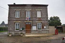 The town hall in Aubéguimont | ||
| ||
 Aubéguimont Location within Normandy region  Aubéguimont | ||
| Coordinates: 49°48′30″N 1°40′26″E / 49.8083°N 1.6739°ECoordinates: 49°48′30″N 1°40′26″E / 49.8083°N 1.6739°E | ||
| Country | France | |
| Region | Normandy | |
| Department | Seine-Maritime | |
| Arrondissement | Dieppe | |
| Canton | Gournay-en-Bray | |
| Intercommunality | CC Aumale - Blangy-sur-Bresle | |
| Government | ||
| • Mayor (2014-2020) | Jacky Baudon | |
| Area1 | 4.85 km2 (1.87 sq mi) | |
| Population (2015)2 | 201 | |
| • Density | 41/km2 (110/sq mi) | |
| Time zone | UTC+1 (CET) | |
| • Summer (DST) | UTC+2 (CEST) | |
| INSEE/Postal code | 76028 /76390 | |
| Elevation |
133–211 m (436–692 ft) (avg. 211 m or 692 ft) | |
|
1 French Land Register data, which excludes lakes, ponds, glaciers > 1 km2 (0.386 sq mi or 247 acres) and river estuaries. 2 Population without double counting: residents of multiple communes (e.g., students and military personnel) only counted once. | ||

Aubéguimont is a commune in the Seine-Maritime department in the Normandy region in northern France.
Geography
A small farming and forestry village in the Pays de Bray, situated some 28 miles (45 km) southeast of Dieppe on the D60 road.
Population
| Year | 1962 | 1968 | 1975 | 1982 | 1990 | 1999 | 2006 | 2015 |
|---|---|---|---|---|---|---|---|---|
| Population | 194 | 208 | 172 | 160 | 167 | 176 | 172 | 201 |
| From the year 1962 on: No double counting—residents of multiple communes (e.g. students and military personnel) are counted only once. | ||||||||
Places of interest
- The church of St.Catherine, dating from the twelfth century.
- The forest of Eu.
See also
References
External links
| Wikimedia Commons has media related to Aubéguimont. |
- Aubéguimont on the Quid website (in French)
This article is issued from
Wikipedia.
The text is licensed under Creative Commons - Attribution - Sharealike.
Additional terms may apply for the media files.