Beuzevillette
| Beuzevillette | ||
|---|---|---|
| Commune | ||
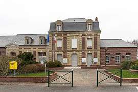 The town hall and school in Beuzevillette | ||
| ||
 Beuzevillette Location within Normandy region  Beuzevillette | ||
| Coordinates: 49°34′22″N 0°32′13″E / 49.5728°N 0.5369°ECoordinates: 49°34′22″N 0°32′13″E / 49.5728°N 0.5369°E | ||
| Country | France | |
| Region | Normandy | |
| Department | Seine-Maritime | |
| Arrondissement | Le Havre | |
| Canton | Bolbec | |
| Intercommunality | CA Caux vallée de Seine | |
| Area1 | 5.63 km2 (2.17 sq mi) | |
| Population (2006)2 | 703 | |
| • Density | 120/km2 (320/sq mi) | |
| Time zone | UTC+1 (CET) | |
| • Summer (DST) | UTC+2 (CEST) | |
| INSEE/Postal code | 76092 /76210 | |
| Elevation |
56–154 m (184–505 ft) (avg. 156 m or 512 ft) | |
|
1 French Land Register data, which excludes lakes, ponds, glaciers > 1 km2 (0.386 sq mi or 247 acres) and river estuaries. 2 Population without double counting: residents of multiple communes (e.g., students and military personnel) only counted once. | ||
Beuzevillette is a commune in the Seine-Maritime department in the Normandy region in northern France.
Heraldry
.svg.png) |
The arms of Beuzevillette are blazoned : Argent, on a cross between in bend 2 (trefoil surmounted by a cross of Calvary of 2 steps) and in bend sinister 2 ermine spots gules, an alerion Or. |
Geography
A farming village situated in the Pays de Caux, surrounded by woodland, some 16 miles (26 km) northeast of Le Havre, just off the D30 road.
Population
| Year | 1962 | 1968 | 1975 | 1982 | 1990 | 1999 | 2006 |
|---|---|---|---|---|---|---|---|
| Population | 588 | 590 | 624 | 687 | 717 | 650 | 703 |
| From the year 1962 on: No double counting—residents of multiple communes (e.g. students and military personnel) are counted only once. | |||||||
Places of interest
- The church of St.Aubin, dating from the twelfth century.
- A thirteenth-century stone cross.
See also
References
External links
| Wikimedia Commons has media related to Beuzevillette. |
- Beuzevillette on the Quid website (in French)
This article is issued from
Wikipedia.
The text is licensed under Creative Commons - Attribution - Sharealike.
Additional terms may apply for the media files.