Nolléval
| Nolléval | ||
|---|---|---|
| Commune | ||
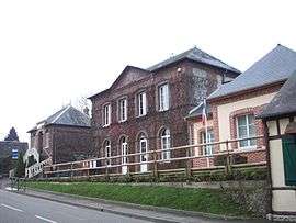 The town hall in Nolléval | ||
| ||
 Nolléval Location within Normandy region  Nolléval | ||
| Coordinates: 49°29′41″N 1°28′56″E / 49.4947°N 1.4822°ECoordinates: 49°29′41″N 1°28′56″E / 49.4947°N 1.4822°E | ||
| Country | France | |
| Region | Normandy | |
| Department | Seine-Maritime | |
| Arrondissement | Dieppe | |
| Canton | Gournay-en-Bray | |
| Intercommunality | CC 4 rivières | |
| Government | ||
| • Mayor | Jacques Carre | |
| Area1 | 9.93 km2 (3.83 sq mi) | |
| Population (2006)2 | 394 | |
| • Density | 40/km2 (100/sq mi) | |
| Time zone | UTC+1 (CET) | |
| • Summer (DST) | UTC+2 (CEST) | |
| INSEE/Postal code | 76469 /76780 | |
| Elevation |
71–206 m (233–676 ft) (avg. 82 m or 269 ft) | |
|
1 French Land Register data, which excludes lakes, ponds, glaciers > 1 km2 (0.386 sq mi or 247 acres) and river estuaries. 2 Population without double counting: residents of multiple communes (e.g., students and military personnel) only counted once. | ||
.svg.png)
Nolléval is a commune in the Seine-Maritime department in the Normandy region in north-western France.
Geography
A forestry and farming village situated by the banks of the river Andelle in the Pays de Bray, at the junction of the D 921, D 38 and D 262 roads, some 16 miles (26 km) east of Rouen.
Population
| 1962 | 1968 | 1975 | 1982 | 1990 | 1999 | 2006 |
|---|---|---|---|---|---|---|
| 383 | 412 | 402 | 347 | 335 | 303 | 394 |
| Starting in 1962: Population without duplicates | ||||||
Places of interest
- The church of St.Aubin, dating from the thirteenth century.
- The church of St.Martin, at the hamlet of Boulay, dating from the seventeenth century.
- The thirteenth century chapel at Montagny.
See also
References
External links
| Wikimedia Commons has media related to Nolléval. |
- Nolléval on the Quid website (in French)
This article is issued from
Wikipedia.
The text is licensed under Creative Commons - Attribution - Sharealike.
Additional terms may apply for the media files.