Aumale
| Aumale | ||
|---|---|---|
| Commune | ||
 The town centre and church in Aumale | ||
| ||
 Aumale Location within Normandy region  Aumale | ||
| Coordinates: 49°46′17″N 1°45′11″E / 49.7714°N 1.7531°ECoordinates: 49°46′17″N 1°45′11″E / 49.7714°N 1.7531°E | ||
| Country | France | |
| Region | Normandy | |
| Department | Seine-Maritime | |
| Arrondissement | Dieppe | |
| Canton | Gournay-en-Bray | |
| Intercommunality | CC Aumale - Blangy-sur-Bresle | |
| Government | ||
| • Mayor (2014-2020) | Virginie Lucot-Avril | |
| Area1 | 9.06 km2 (3.50 sq mi) | |
| Population (2015)2 | 2,177 | |
| • Density | 240/km2 (620/sq mi) | |
| Time zone | UTC+1 (CET) | |
| • Summer (DST) | UTC+2 (CEST) | |
| INSEE/Postal code | 76035 /76390 | |
| Elevation |
106–212 m (348–696 ft) (avg. 130 m or 430 ft) | |
|
1 French Land Register data, which excludes lakes, ponds, glaciers > 1 km2 (0.386 sq mi or 247 acres) and river estuaries. 2 Population without double counting: residents of multiple communes (e.g., students and military personnel) only counted once. | ||
Aumale, formerly known as Albemarle,[1] is a commune in the Seine-Maritime department in the Normandy region in north-western France. It lies on the river Bresle.
History
The town's Latin name was Alba Marla. It was raised by William the Bastard into a county, which was held by the houses of Castile, Dammartin, Harcourt, and Lorraine. In 1547, it was raised to the status of a duchy for Francis of Lorraine. It passed to the house of Savoy, from whom Louis XIV purchased the title in 1675 in order to bestow it upon one of his bastards as an appanage. In 1769, it passed to the house of Orleans.[1] The British Earls of Albemarle, meanwhile, also derive their name from the area.[1]
Geography
A village of farming and associated light industry, situated in the valley of the Bresle River of the Norman Pays de Bray in Normandy on the border with Picardie. It is around 34 miles (55 km) southeast of Dieppe at the junction of the D 916, D 920, D 929 and D 49 roads. The A29 autoroute (Saint-Quentin-Beuzeville) passes through the commune’s northern sector. SNCF, the French railway has a TER station here, on the Beauvais – Le Tréport-Mers line.
Heraldry
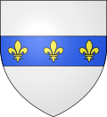 |
The arms of Aumale are blazoned : Argent, on a fess azure, 3 fleurs de lys Or. |
Population
| Year | 1962 | 1968 | 1975 | 1982 | 1990 | 1999 | 2006 | 2015 |
|---|---|---|---|---|---|---|---|---|
| Population | 2716 | 2833 | 2825 | 2876 | 2690 | 2577 | 2544 | 2177 |
| From the year 1962 on: No double counting—residents of multiple communes (e.g. students and military personnel) are counted only once. | ||||||||
Places of interest
- The church of St.Pierre & St.Paul, dating from the sixteenth century.
- The sixteenth-century Hôtel de ville (town hall).
- A seventeenth-century Hospital.
- The chapel of Notre-Dame du Cardonnoy, from the thirteenth century.
- The seventeenth-century château du Bois Robin
- The tower and buildings of the 16th-century abbey.
Twin towns
See also
Notes
- 1 2 3 "

References
External links
| Wikimedia Commons has media related to Aumale (Seine-Maritime). |
- Aumale official website (in French)
- Aumale on the Quid website (in French)
 Aumale church
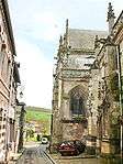 North side of the church
 Sculpted wood panels on the pulpit
 The Bresle river by the Moulin du Roy