Houdetot
| Houdetot | |
|---|---|
| Commune | |
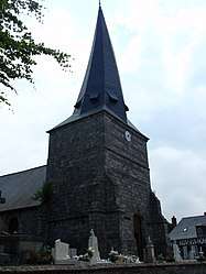 The church in Houdetot | |
 Houdetot Location within Normandy region  Houdetot | |
| Coordinates: 49°48′54″N 0°48′14″E / 49.815°N 0.8039°ECoordinates: 49°48′54″N 0°48′14″E / 49.815°N 0.8039°E | |
| Country | France |
| Region | Normandy |
| Department | Seine-Maritime |
| Arrondissement | Dieppe |
| Canton | Saint-Valery-en-Caux |
| Intercommunality | CC Côte d'Albâtre |
| Government | |
| • Mayor | Jean-François Bocquet |
| Area1 | 5.77 km2 (2.23 sq mi) |
| Population (2006)2 | 166 |
| • Density | 29/km2 (75/sq mi) |
| Time zone | UTC+1 (CET) |
| • Summer (DST) | UTC+2 (CEST) |
| INSEE/Postal code | 76365 /76740 |
| Elevation |
63–103 m (207–338 ft) (avg. 85 m or 279 ft) |
|
1 French Land Register data, which excludes lakes, ponds, glaciers > 1 km2 (0.386 sq mi or 247 acres) and river estuaries. 2 Population without double counting: residents of multiple communes (e.g., students and military personnel) only counted once. | |
Houdetot is a commune in the Seine-Maritime department in the Normandy region in northern France.
Geography
A small farming village in the Pays de Caux situated some 17 miles (27 km) southwest of Dieppe at the junction of the D70 and the D437 roads.
Population
| Year | 1962 | 1968 | 1975 | 1982 | 1990 | 1999 | 2006 |
|---|---|---|---|---|---|---|---|
| Population | 141 | 167 | 153 | 135 | 136 | 135 | 166 |
| From the year 1962 on: No double counting—residents of multiple communes (e.g. students and military personnel) are counted only once. | |||||||
Places of interest
- The church of St.Pierre, dating from the thirteenth century.
- Traces of a castle dating from medieval times.
See also
References
External links
| Wikimedia Commons has media related to Houdetot. |
- Houdetot on the Quid website (in French)
This article is issued from
Wikipedia.
The text is licensed under Creative Commons - Attribution - Sharealike.
Additional terms may apply for the media files.