Jumièges
| Jumièges | ||
|---|---|---|
| Commune | ||
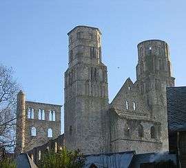 Ruins of the abbey of Jumièges | ||
| ||
 Jumièges Location within Normandy region  Jumièges | ||
| Coordinates: 49°26′04″N 0°49′17″E / 49.4344°N 0.8214°ECoordinates: 49°26′04″N 0°49′17″E / 49.4344°N 0.8214°E | ||
| Country | France | |
| Region | Normandy | |
| Department | Seine-Maritime | |
| Arrondissement | Rouen | |
| Canton | Barentin | |
| Intercommunality | Métropole Rouen-Normandie | |
| Government | ||
| • Mayor (2014–2020) | Jean Dupont | |
| Area1 | 18.75 km2 (7.24 sq mi) | |
| Population (2014)2 | 1,778 | |
| • Density | 95/km2 (250/sq mi) | |
| Time zone | UTC+1 (CET) | |
| • Summer (DST) | UTC+2 (CEST) | |
| INSEE/Postal code | 76378 /76480 | |
| Elevation |
0–83 m (0–272 ft) (avg. 8 m or 26 ft) | |
|
1 French Land Register data, which excludes lakes, ponds, glaciers > 1 km2 (0.386 sq mi or 247 acres) and river estuaries. 2 Population without double counting: residents of multiple communes (e.g., students and military personnel) only counted once. | ||
Jumièges is a commune in the Seine-Maritime department in the Normandy region in north-western France.
Geography
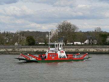
A forestry and farming village situated in a meander of the river Seine, some 21 kilometres (13 mi) west of Rouen, at the junction of the D 65 and the D 143 roads. A ferry service operates here, connecting the commune with the south and west sides of the river.
Heraldry
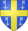 |
The arms of Jumièges are blazoned : Azure, a cross Or between 4 keys addorsed argent. |
Demography
| Historical population | ||
|---|---|---|
| Year | Pop. | ±% |
| 1793 | 1,694 | — |
| 1800 | 1,850 | +9.2% |
| 1806 | 1,862 | +0.6% |
| 1821 | 1,955 | +5.0% |
| 1831 | 1,847 | −5.5% |
| 1836 | 1,711 | −7.4% |
| 1841 | 1,678 | −1.9% |
| 1846 | 1,674 | −0.2% |
| 1851 | 1,765 | +5.4% |
| 1856 | 1,670 | −5.4% |
| 1861 | 1,602 | −4.1% |
| 1866 | 1,618 | +1.0% |
| 1872 | 1,073 | −33.7% |
| 1876 | 1,084 | +1.0% |
| 1881 | 1,015 | −6.4% |
| 1886 | 1,028 | +1.3% |
| 1891 | 1,027 | −0.1% |
| 1896 | 1,020 | −0.7% |
| 1901 | 995 | −2.5% |
| 1906 | 1,012 | +1.7% |
| 1911 | 928 | −8.3% |
| 1921 | 872 | −6.0% |
| 1926 | 847 | −2.9% |
| 1931 | 867 | +2.4% |
| 1936 | 880 | +1.5% |
| 1946 | 1,078 | +22.5% |
| 1954 | 1,088 | +0.9% |
| 1962 | 1,214 | +11.6% |
| 1968 | 1,305 | +7.5% |
| 1975 | 1,474 | +13.0% |
| 1982 | 1,634 | +10.9% |
| 1990 | 1,641 | +0.4% |
| 1999 | 1,714 | +4.4% |
| 2006 | 1,715 | +0.1% |
| 2007 | 1,715 | +0.0% |
| 2008 | 1,718 | +0.2% |
| 2009 | 1,719 | +0.1% |
| 2010 | 1,736 | +1.0% |
| 2011 | 1,753 | +1.0% |
| 2012 | 1,769 | +0.9% |
| 2013 | 1,767 | −0.1% |
| 2014 | 1,778 | +0.6% |
Places of interest
- The church of St. Valentin, dating from the eleventh century.
- The ruins of the tenth-century church of St.Pierre.
- An eighteenth-century chapel.
- Several lesser buildings dating from the eleventh century.
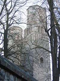
Jumièges Abbey
It is best known as the site of Jumièges Abbey, a typical Norman abbey of the Romanesque period, and the home of the pro-Norman chronicler William of Jumièges who wrote the Gesta Normannorum Ducum about 1070. Now ruined, the abbey dates from 1067, when it was consecrated in the presence of William the Conqueror[1]
People linked with the commune
- Maurice Leblanc, writer.
- Roger Martin du Gard, writer.
See also
References
External links
| Wikimedia Commons has media related to Jumièges. |
- History website of Jumièges (in French)
- Jumièges on the Quid website (in French)
- The abbey at the Circulo Romanco