Saint-Germain-des-Essourts
| Saint-Germain-des-Essourts | |
|---|---|
| Commune | |
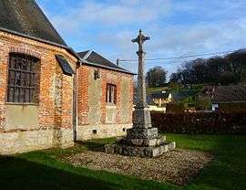 The cemetery cross in Saint-Germain-des-Essourts | |
 Saint-Germain-des-Essourts Location within Normandy region  Saint-Germain-des-Essourts | |
| Coordinates: 49°32′22″N 1°19′14″E / 49.5394°N 1.3206°ECoordinates: 49°32′22″N 1°19′14″E / 49.5394°N 1.3206°E | |
| Country | France |
| Region | Normandy |
| Department | Seine-Maritime |
| Arrondissement | Rouen |
| Canton | Le Mesnil-Esnard |
| Government | |
| • Mayor (2001–2008) | Jean-Michel Duval |
| Area1 | 9.37 km2 (3.62 sq mi) |
| Population (2006)2 | 364 |
| • Density | 39/km2 (100/sq mi) |
| Time zone | UTC+1 (CET) |
| • Summer (DST) | UTC+2 (CEST) |
| INSEE/Postal code | 76581 /76750 |
| Elevation |
101–171 m (331–561 ft) (avg. 128 m or 420 ft) |
|
1 French Land Register data, which excludes lakes, ponds, glaciers > 1 km2 (0.386 sq mi or 247 acres) and river estuaries. 2 Population without double counting: residents of multiple communes (e.g., students and military personnel) only counted once. | |
Saint-Germain-des-Essourts is a commune in the Seine-Maritime department in the Normandy region in northern France.
Geography
A farming village situated in the Pays de Bray, some 14 miles (23 km) northeast of Rouen at the junction of the D98 with the D87 and the D7 with the D61 roads. The commune’s territory is the source of the river Crevon, a small tributary of the Andelle river.
Population
| 1962 | 1968 | 1975 | 1982 | 1990 | 1999 | 2006 |
|---|---|---|---|---|---|---|
| 260 | 245 | 247 | 247 | 329 | 352 | 364 |
| Starting in 1962: Population without duplicates | ||||||
Places of interest
- The church of St. Germain, dating from the nineteenth century.
- A sixteenth-century stone cross.
- The nineteenth-century chateau of Fontaine-Châtel.
- The chateau of Bimare.
- The chapel of St. Austreberthe.
See also
References
External links
| Wikimedia Commons has media related to Saint-Germain-des-Essourts. |
- Saint-Germain-des-Essourts on the Quid website (in French)
This article is issued from
Wikipedia.
The text is licensed under Creative Commons - Attribution - Sharealike.
Additional terms may apply for the media files.