Berville, Seine-Maritime
| Berville | |
|---|---|
| Commune | |
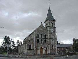 The church in Berville | |
 Berville Location within Normandy region  Berville | |
| Coordinates: 49°42′36″N 0°50′00″E / 49.71°N 0.8333°ECoordinates: 49°42′36″N 0°50′00″E / 49.71°N 0.8333°E | |
| Country | France |
| Region | Normandy |
| Department | Seine-Maritime |
| Arrondissement | Rouen |
| Canton | Yvetot |
| Intercommunality | CC Plateau de Caux-Doudeville-Yerville |
| Government | |
| • Mayor (2012-2014) | François-Marie Berger |
| Area1 | 6.72 km2 (2.59 sq mi) |
| Population (2009)2 | 544 |
| • Density | 81/km2 (210/sq mi) |
| Time zone | UTC+1 (CET) |
| • Summer (DST) | UTC+2 (CEST) |
| INSEE/Postal code | 76087 /76560 |
| Elevation |
123–164 m (404–538 ft) (avg. 150 m or 490 ft) |
|
1 French Land Register data, which excludes lakes, ponds, glaciers > 1 km2 (0.386 sq mi or 247 acres) and river estuaries. 2 Population without double counting: residents of multiple communes (e.g., students and military personnel) only counted once. | |
Berville, also Berville-en-Caux, is a commune in the Seine-Maritime department in the Normandy region in north-western France.
Geography
A farming village situated in the Pays de Caux, some 30 miles (48 km) northwest of Rouen, at the junction of the D67 and the D27 roads.
Population
| Year | 1962 | 1968 | 1975 | 1982 | 1990 | 1999 | 2006 | 2009 |
|---|---|---|---|---|---|---|---|---|
| Population | 369 | 380 | 411 | 419 | 473 | 480 | 541 | 544 |
| From the year 1962 on: No double counting—residents of multiple communes (e.g. students and military personnel) are counted only once. | ||||||||
Places of interest
- The church of Saint-Wandrille, dating from the nineteenth century.
- The eighteenth century chapel of Saint-Gilles.
See also
References
| Wikimedia Commons has media related to Berville (Seine-Maritime). |
This article is issued from
Wikipedia.
The text is licensed under Creative Commons - Attribution - Sharealike.
Additional terms may apply for the media files.