Clères
| Clères | ||
|---|---|---|
| Commune | ||
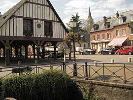 The covered marketplace in Clères | ||
| ||
 Clères Location within Normandy region  Clères | ||
| Coordinates: 49°36′01″N 1°06′40″E / 49.6003°N 1.1111°ECoordinates: 49°36′01″N 1°06′40″E / 49.6003°N 1.1111°E | ||
| Country | France | |
| Region | Normandy | |
| Department | Seine-Maritime | |
| Arrondissement | Rouen | |
| Canton | Bois-Guillaume | |
| Intercommunality | Communauté de communes des Portes Nord-Ouest de Rouen | |
| Government | ||
| • Mayor (2014-2020) | Nathalie Thierry | |
| Area1 | 11.36 km2 (4.39 sq mi) | |
| Population (2011)2 | 1,361 | |
| • Density | 120/km2 (310/sq mi) | |
| Time zone | UTC+1 (CET) | |
| • Summer (DST) | UTC+2 (CEST) | |
| INSEE/Postal code | 76179 /76690 | |
| Elevation |
63–181 m (207–594 ft) (avg. 113 m or 371 ft) | |
|
1 French Land Register data, which excludes lakes, ponds, glaciers > 1 km2 (0.386 sq mi or 247 acres) and river estuaries. 2 Population without double counting: residents of multiple communes (e.g., students and military personnel) only counted once. | ||
Clères is a commune in the Seine-Maritime department in the Normandy region in north-western France.
Geography
A farming and forestry market town situated by the banks of the Clérette river, in the Pays de Caux, some 17 miles (27 km) northeast of Rouen, at the junction of the D 2, D 6, D 53 and the D 100 roads. SNCF has a TER railway station in the town.
Heraldry
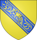 |
The arms of Clères are blazoned : Argent, a bend azure diapered Or, charged with a flamingo Or. |
Population
| Year | 1793 | 1821 | 1962 | 1968 | 1975 | 1982 | 1990 | 1999 | 2006 | 2008 | 2011 |
|---|---|---|---|---|---|---|---|---|---|---|---|
| Population | 560 | 511 | 1006 | 1055 | 1091 | 1302 | 1254 | 1266 | 1303 | 1313 | 1361 |
| From the year 1962 on: No double counting—residents of multiple communes (e.g. students and military personnel) are counted only once. | |||||||||||
Places of interest
- The church of Sts. Waast-&-Nicolas, dating from the sixteenth century.
- The church of St. Sauveur at Cordelleville, dating from the twelfth century.
- The church of Notre-Dame at Le Tôt, dating from the twelfth century.
- A château and its park, home of the zoo.
- A seventeenth century sandstone cross.
- Ruins of a medieval castle.
- Several ancient wood-framed houses.
- The eighteenth century market hall ‘Les Halles’.
People with links to the commune
- Jean Delacour, ornithologist, lived here.
Twin towns

See also
References
Bibliography
- Hippolyte Lemarchand, Histoire du canton de Clères, 1891 ; Le Pucheux, Fontaine-le-Bourg, 2002 ISBN 2-9517552-2-8
External links
| Wikimedia Commons has media related to Clères. |
- Clare, Clere, and Clères A paper on the origin of the town's name.
- Tourist Office website (in French)
- Clères on the Quid website (in French)
- Site perso sur CLERES (in French)
This article is issued from
Wikipedia.
The text is licensed under Creative Commons - Attribution - Sharealike.
Additional terms may apply for the media files.