Grumesnil
| Grumesnil | |
|---|---|
| Commune | |
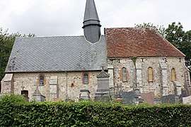 The chapel of Saint-Pierre-mi-les-Camps | |
 Grumesnil Location within Normandy region  Grumesnil | |
| Coordinates: 49°36′36″N 1°41′36″E / 49.61°N 1.6933°ECoordinates: 49°36′36″N 1°41′36″E / 49.61°N 1.6933°E | |
| Country | France |
| Region | Normandy |
| Department | Seine-Maritime |
| Arrondissement | Dieppe |
| Canton | Gournay-en-Bray |
| Intercommunality | CC 4 rivières |
| Government | |
| • Mayor | Michel Buquet |
| Area1 | 11.16 km2 (4.31 sq mi) |
| Population (2006)2 | 490 |
| • Density | 44/km2 (110/sq mi) |
| Time zone | UTC+1 (CET) |
| • Summer (DST) | UTC+2 (CEST) |
| INSEE/Postal code | 76332 /76440 |
| Elevation |
167–229 m (548–751 ft) (avg. 170 m or 560 ft) |
|
1 French Land Register data, which excludes lakes, ponds, glaciers > 1 km2 (0.386 sq mi or 247 acres) and river estuaries. 2 Population without double counting: residents of multiple communes (e.g., students and military personnel) only counted once. | |
Grumesnil is a commune in the Seine-Maritime department in the Normandy region in northern France.
Geography
Grumesnil is a farming village situated in the Pays de Bray, some 40 miles (64 km) southeast of Dieppe at the junction of the D105 and the D8 roads. The commune borders the neighbouring département of Oise.
Population
| Year | 1962 | 1968 | 1975 | 1982 | 1990 | 1999 | 2006 |
|---|---|---|---|---|---|---|---|
| Population | 328 | 367 | 325 | 333 | 335 | 403 | 490 |
| From the year 1962 on: No double counting—residents of multiple communes (e.g. students and military personnel) are counted only once. | |||||||
Places of interest
- The church of St.Pierre, dating from the thirteenth century.
- An eleventh-century chapel.
- The seventeenth-century chateau.
See also
References
External links
| Wikimedia Commons has media related to Grumesnil. |
- Grumesnil on the Quid website (in French)
This article is issued from
Wikipedia.
The text is licensed under Creative Commons - Attribution - Sharealike.
Additional terms may apply for the media files.