Alvimare
| Alvimare | |
|---|---|
| Commune | |
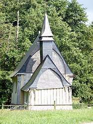 The Chapelle des Blanques | |
 Alvimare Location within Normandy region  Alvimare | |
| Coordinates: 49°36′23″N 0°37′57″E / 49.6064°N 0.6325°ECoordinates: 49°36′23″N 0°37′57″E / 49.6064°N 0.6325°E | |
| Country | France |
| Region | Normandy |
| Department | Seine-Maritime |
| Arrondissement | Le Havre |
| Canton | Saint-Valery-en-Caux |
| Intercommunality | CA Caux vallée de Seine |
| Government | |
| • Mayor (2014-2020) | Michel Lemercier |
| Area1 | 6.73 km2 (2.60 sq mi) |
| Population (2014)2 | 634 |
| • Density | 94/km2 (240/sq mi) |
| Time zone | UTC+1 (CET) |
| • Summer (DST) | UTC+2 (CEST) |
| INSEE/Postal code | 76002 /76640 |
| Elevation |
129–153 m (423–502 ft) (avg. 140 m or 460 ft) |
|
1 French Land Register data, which excludes lakes, ponds, glaciers > 1 km2 (0.386 sq mi or 247 acres) and river estuaries. 2 Population without double counting: residents of multiple communes (e.g., students and military personnel) only counted once. | |
Alvimare is a commune in the Seine-Maritime department in the Normandy region in northern France.
Geography
A farming village situated some 23 miles (37 km) east of Le Havre, at the junction of the N15 and the D104.
Population
| Year | 1962 | 1968 | 1975 | 1982 | 1990 | 1999 | 2006 |
|---|---|---|---|---|---|---|---|
| Population | 304 | 330 | 294 | 360 | 486 | 462 | 501 |
| From the year 1962 on: No double counting—residents of multiple communes (e.g. students and military personnel) are counted only once. | |||||||
Places of interest
- The wooden chapel dating from the sixteenth century.
- A sixteenth-century manorhouse
- The church of Notre-Dame, dating from the nineteenth century
- A fifteenth-century stone cross.
See also
References
External links
| Wikimedia Commons has media related to Alvimare. |
- Alvimare on the Quid website (in French)
This article is issued from
Wikipedia.
The text is licensed under Creative Commons - Attribution - Sharealike.
Additional terms may apply for the media files.