Saint-Pierre-de-Manneville
| Saint-Pierre-de-Manneville | ||
|---|---|---|
| Commune | ||
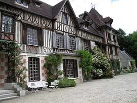 The manor of Villers | ||
| ||
 Saint-Pierre-de-Manneville Location within Normandy region  Saint-Pierre-de-Manneville | ||
| Coordinates: 49°23′36″N 0°55′57″E / 49.3933°N 0.9325°ECoordinates: 49°23′36″N 0°55′57″E / 49.3933°N 0.9325°E | ||
| Country | France | |
| Region | Normandy | |
| Department | Seine-Maritime | |
| Arrondissement | Rouen | |
| Canton | Canteleu | |
| Intercommunality | Métropole Rouen Normandie | |
| Government | ||
| • Mayor | Nelly Tocqueville | |
| Area1 | 10.21 km2 (3.94 sq mi) | |
| Population (2006)2 | 745 | |
| • Density | 73/km2 (190/sq mi) | |
| Time zone | UTC+1 (CET) | |
| • Summer (DST) | UTC+2 (CEST) | |
| INSEE/Postal code | 76634 /76113 | |
| Elevation |
1–114 m (3.3–374.0 ft) (avg. 6 m or 20 ft) | |
|
1 French Land Register data, which excludes lakes, ponds, glaciers > 1 km2 (0.386 sq mi or 247 acres) and river estuaries. 2 Population without double counting: residents of multiple communes (e.g., students and military personnel) only counted once. | ||
Saint-Pierre-de-Manneville is a commune in the Seine-Maritime department in the Normandy region in northern France.
Geography
A village of forestry, farming and associated light industry situated in a meander of the Seine, some 7 miles (11 km) southwest of Rouen on the D67 road.
Heraldry
 |
The arms of Saint-Pierre-de-Manneville are blazoned : Or, a bend wavy azure between a bunch of grapes gules, slipped and leaved vert, and a fir tree eradicated vert, and on a chief gules, 3 angennes argent. [1] |
Population
| 1962 | 1968 | 1975 | 1982 | 1990 | 1999 | 2006 |
|---|---|---|---|---|---|---|
| 432 | 442 | 501 | 571 | 728 | 774 | 745 |
| Starting from 1962: Population without duplicates | ||||||
Places of interest
- The church of St. Pierre, dating from the sixteenth century.
- The chapel at Villiers, dating from the eighteenth century.
- The nineteenth-century chateau of BelleGarde.
- The manorhouse at Villers, built in timber and dating from the sixteenth century.
- Two mansions.
See also
References
- ↑ (Note: this angenne is very rose-like, not the highly stylized cinqfoil.)
External links
| Wikimedia Commons has media related to Saint-Pierre-de-Manneville. |
- Official website of Saint-Pierre-de-Manneville (in French)
- Saint-Pierre-de-Manneville on the Quid website (in French)
This article is issued from
Wikipedia.
The text is licensed under Creative Commons - Attribution - Sharealike.
Additional terms may apply for the media files.