Torcy-le-Petit, Seine-Maritime
| Torcy-le-Petit | ||
|---|---|---|
| Commune | ||
| ||
 Torcy-le-Petit Location within Normandy region  Torcy-le-Petit | ||
| Coordinates: 49°48′50″N 1°10′27″E / 49.8139°N 1.1742°ECoordinates: 49°48′50″N 1°10′27″E / 49.8139°N 1.1742°E | ||
| Country | France | |
| Region | Normandy | |
| Department | Seine-Maritime | |
| Arrondissement | Dieppe | |
| Canton | Luneray | |
| Intercommunality | CC Terroir de Caux | |
| Government | ||
| • Mayor (2008–2014) | Jean-Pierre Paumier | |
| Area1 | 3.66 km2 (1.41 sq mi) | |
| Population (2010)2 | 489 | |
| • Density | 130/km2 (350/sq mi) | |
| Time zone | UTC+1 (CET) | |
| • Summer (DST) | UTC+2 (CEST) | |
| INSEE/Postal code | 76698 /76590 | |
| Elevation |
22–150 m (72–492 ft) (avg. 38 m or 125 ft) | |
|
1 French Land Register data, which excludes lakes, ponds, glaciers > 1 km2 (0.386 sq mi or 247 acres) and river estuaries. 2 Population without double counting: residents of multiple communes (e.g., students and military personnel) only counted once. | ||
Torcy-le-Petit is a commune in the Seine-Maritime department in the Normandy region in north-western France.
Geography
A farming village situated in the Pays de Caux and by the banks of the Varenne River, some 7 miles (11 km) south of Dieppe at the junction of the D 915 and the D 149 roads.
Heraldry
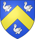 |
The arms of Torcy-le-Petit are blazoned : Azure, a chevron Or between 3 martlets argent. |
Population
| 1962 | 1968 | 1975 | 1982 | 1990 | 1999 | 2006 | 2010 |
|---|---|---|---|---|---|---|---|
| 521 | 521 | 511 | 442 | 491 | 474 | 469 | 489 |
| Starting in 1962: Population without duplicates | |||||||
Places of interest
- The church of St. Denis, dating from the thirteenth century.
See also
References
External links
| Wikimedia Commons has media related to Torcy-le-Petit (Seine-Maritime). |
- Torcy-le-Petit on the Quid website (in French)
This article is issued from
Wikipedia.
The text is licensed under Creative Commons - Attribution - Sharealike.
Additional terms may apply for the media files.