Bretteville-Saint-Laurent
| Bretteville-Saint-Laurent | |
|---|---|
| Commune | |
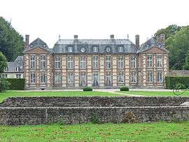 The chateau in Bretteville-Saint-Laurent | |
 Bretteville-Saint-Laurent Location within Normandy region  Bretteville-Saint-Laurent | |
| Coordinates: 49°45′50″N 0°52′32″E / 49.7639°N 0.8756°ECoordinates: 49°45′50″N 0°52′32″E / 49.7639°N 0.8756°E | |
| Country | France |
| Region | Normandy |
| Department | Seine-Maritime |
| Arrondissement | Rouen |
| Canton | Yvetot |
| Intercommunality | CC Plateau de Caux-Doudeville-Yerville |
| Government | |
| • Mayor | Philippe Cote |
| Area1 | 3.97 km2 (1.53 sq mi) |
| Population (2006)2 | 168 |
| • Density | 42/km2 (110/sq mi) |
| Time zone | UTC+1 (CET) |
| • Summer (DST) | UTC+2 (CEST) |
| INSEE/Postal code | 76144 /76560 |
| Elevation |
95–140 m (312–459 ft) (avg. 145 m or 476 ft) |
|
1 French Land Register data, which excludes lakes, ponds, glaciers > 1 km2 (0.386 sq mi or 247 acres) and river estuaries. 2 Population without double counting: residents of multiple communes (e.g., students and military personnel) only counted once. | |
Bretteville-Saint-Laurent is a commune in the Seine-Maritime department in the Normandy region in northern France.
Geography
A small farming village situated in the Pays de Caux some 19 miles (31 km) southwest of Dieppe, at the junction of the D107, D142 and the D103 roads.
Population
| Year | 1962 | 1968 | 1975 | 1982 | 1990 | 1999 | 2006 |
|---|---|---|---|---|---|---|---|
| Population | 94 | 135 | 136 | 169 | 186 | 183 | 168 |
| From the year 1962 on: No double counting—residents of multiple communes (e.g. students and military personnel) are counted only once. | |||||||
Places of interest
- The church of Notre-Dame, dating from the thirteenth century.
- An eighteenth-century chateau.
See also
References
External links
| Wikimedia Commons has media related to Bretteville-Saint-Laurent. |
- Bretteville-Saint-Laurent on the Quid website (in French)
This article is issued from
Wikipedia.
The text is licensed under Creative Commons - Attribution - Sharealike.
Additional terms may apply for the media files.