Hodeng-au-Bosc
| Hodeng-au-Bosc | |
|---|---|
| Commune | |
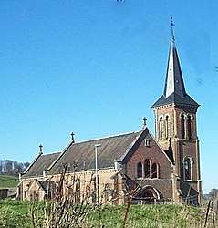 The church in Hodeng-au-Bosc | |
 Hodeng-au-Bosc Location within Normandy region  Hodeng-au-Bosc | |
| Coordinates: 49°51′46″N 1°42′30″E / 49.8628°N 1.7083°ECoordinates: 49°51′46″N 1°42′30″E / 49.8628°N 1.7083°E | |
| Country | France |
| Region | Normandy |
| Department | Seine-Maritime |
| Arrondissement | Dieppe |
| Canton | Eu |
| Intercommunality | CC Aumale - Blangy-sur-Bresle |
| Government | |
| • Mayor (2008–2014) | Claude Santerre |
| Area1 | 8.77 km2 (3.39 sq mi) |
| Population (2006)2 | 589 |
| • Density | 67/km2 (170/sq mi) |
| Time zone | UTC+1 (CET) |
| • Summer (DST) | UTC+2 (CEST) |
| INSEE/Postal code | 76363 /76340 |
| Elevation |
61–205 m (200–673 ft) (avg. 100 m or 330 ft) |
|
1 French Land Register data, which excludes lakes, ponds, glaciers > 1 km2 (0.386 sq mi or 247 acres) and river estuaries. 2 Population without double counting: residents of multiple communes (e.g., students and military personnel) only counted once. | |
Hodeng-au-Bosc is a commune in the Seine-Maritime department in the Normandy region of northern France.
Geography
A forestry and farming village situated in the valley of the river Bresle in the Pays de Bray, some 33 miles (53 km) southeast of Dieppe at the junction of the D7, the D246 and the D49 roads. The commune also features a glassmaking factory, founded in 1623.
Population
| Year | 1962 | 1968 | 1975 | 1982 | 1990 | 1999 | 2006 |
|---|---|---|---|---|---|---|---|
| Population | 440 | 444 | 507 | 541 | 576 | 555 | 589 |
| From the year 1962 on: No double counting—residents of multiple communes (e.g. students and military personnel) are counted only once. | |||||||
Places of interest
- The church of St.Denis, dating from the nineteenth century.
- The church of St.Sauveur at Guimerville, dating from the sixteenth century.
People
Jean-Luc Thérier, racing driver for the Alpine Renault team in the 1970s, was born here in 1945.
See also
References
External links
| Wikimedia Commons has media related to Hodeng-au-Bosc. |
- Hodeng-au-Bosc on the Quid website (in French)
This article is issued from
Wikipedia.
The text is licensed under Creative Commons - Attribution - Sharealike.
Additional terms may apply for the media files.