Goderville
| Goderville | ||
|---|---|---|
| Commune | ||
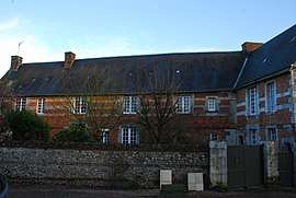 The old chateau in Goderville | ||
| ||
 Goderville Location within Normandy region  Goderville | ||
| Coordinates: 49°38′49″N 0°21′59″E / 49.6469°N 0.3664°ECoordinates: 49°38′49″N 0°21′59″E / 49.6469°N 0.3664°E | ||
| Country | France | |
| Region | Normandy | |
| Department | Seine-Maritime | |
| Arrondissement | Le Havre | |
| Canton | Saint-Romain-de-Colbosc | |
| Intercommunality | CC Campagne de Caux | |
| Government | ||
| • Mayor (2001–2008) | Jacques Bunel | |
| Area1 | 7.98 km2 (3.08 sq mi) | |
| Population (2006)2 | 2,779 | |
| • Density | 350/km2 (900/sq mi) | |
| Time zone | UTC+1 (CET) | |
| • Summer (DST) | UTC+2 (CEST) | |
| INSEE/Postal code | 76302 /76110 | |
| Elevation |
97–134 m (318–440 ft) (avg. 124 m or 407 ft) | |
|
1 French Land Register data, which excludes lakes, ponds, glaciers > 1 km2 (0.386 sq mi or 247 acres) and river estuaries. 2 Population without double counting: residents of multiple communes (e.g., students and military personnel) only counted once. | ||
Goderville is a commune in the Seine-Maritime department in the Normandy region in northern France.
Geography
A farming and light industrial town situated 7 miles (11 km) to the south of Fécamp, at the junction of the D10, D925 and D139 roads, in the Pays de Caux.
History
The first mention of Goderville is on a royal charter in 875 by Charles the Bald. Charles was said to have the most bald head in all of the land. It dealt with the value and number of properties belonging to the chapter of Rouen. The town got its name from the family of Godard of Vaulx, first unknown lord of the manor. In 1492, they allied themselves by marriage to the Roussel family. In March 1651, Goderville was elevated to a baronetcy by letter patent.
Until the French revolution, the town was governed as a ‘sergenterie’.
The market, notable for linen, has existed since the 16th century.
Goderville absorbed the commune of Crétot in 1825.
Heraldry
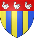 |
The arms of Goderville are blazoned : Paly Or and azure, on a chief gules, 3 martlets argent. |
Population
| Year | 1962 | 1968 | 1975 | 1982 | 1990 | 1999 | 2006 |
|---|---|---|---|---|---|---|---|
| Population | 1395 | 1499 | 1632 | 1885 | 2044 | 2281 | 2779 |
| From the year 1962 on: No double counting—residents of multiple communes (e.g. students and military personnel) are counted only once. | |||||||
Places of interest
Notable people
- Guy de Maupassant based "La Ficelle" in Goderville.
- Jean Prévost (1901–1944), Goderville was the family home of the writer and member of the Maquis, who went by the pseudonym ‘Captain Goderville’.
- Antoine Vincent Arnault (1766–1834), politician, poet and author, member of the Académie française, died at Goderville.
See also
References
External links
| Wikimedia Commons has media related to Goderville. |
- Goderville on the Quid website (in French)