Saint-Martin-du-Bec
| Saint-Martin-du-Bec | ||
|---|---|---|
| Commune | ||
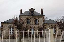 The town hall in Saint-Martin-du-Bec | ||
| ||
 Saint-Martin-du-Bec Location within Normandy region  Saint-Martin-du-Bec | ||
| Coordinates: 49°36′11″N 0°12′39″E / 49.6031°N 0.2108°ECoordinates: 49°36′11″N 0°12′39″E / 49.6031°N 0.2108°E | ||
| Country | France | |
| Region | Normandy | |
| Department | Seine-Maritime | |
| Arrondissement | Le Havre | |
| Canton | Octeville-sur-Mer | |
| Intercommunality | CC Canton de Criquetot-l'Esneval | |
| Area1 | 4.12 km2 (1.59 sq mi) | |
| Population (2006)2 | 649 | |
| • Density | 160/km2 (410/sq mi) | |
| Time zone | UTC+1 (CET) | |
| • Summer (DST) | UTC+2 (CEST) | |
| INSEE/Postal code | 76615 /76133 | |
| Elevation |
44–106 m (144–348 ft) (avg. 80 m or 260 ft) | |
|
1 French Land Register data, which excludes lakes, ponds, glaciers > 1 km2 (0.386 sq mi or 247 acres) and river estuaries. 2 Population without double counting: residents of multiple communes (e.g., students and military personnel) only counted once. | ||
Saint-Martin-du-Bec is a commune in the Seine-Maritime department in the Normandy region in northern France.
Geography
A farming village in the Pays de Caux, situated some 9 miles (14 km) northeast of Le Havre, at the junction of the D32 and D79 roads, by the banks of the river Lézarde.
Heraldry
 |
The arms of Saint-Martin-du-Bec are blazoned : Azure, a leopard in chief 2 crosslets Or, a chief fusilly argent and gules. |
Population
| 1962 | 1968 | 1975 | 1982 | 1990 | 1999 | 2006 |
|---|---|---|---|---|---|---|
| 254 | 282 | 313 | 532 | 580 | 619 | 649 |
| Starting in 1962: Population without duplicates | ||||||
Places of interest
- The church of St. Martin, dating from the twelfth century.
- The castle of Bec-Crespin, with a thirteenth-century gate and portcullis.
- Old buildings, parkland and lakes of the castle grounds.
See also
References
External links
| Wikimedia Commons has media related to Saint-Martin-du-Bec. |
- Saint-Martin-du-Bec on the Quid website (in French)
This article is issued from
Wikipedia.
The text is licensed under Creative Commons - Attribution - Sharealike.
Additional terms may apply for the media files.