Canville-les-Deux-Églises
| Canville-les-Deux-Églises | |
|---|---|
| Commune | |
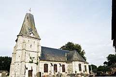 The church in Canville | |
 Canville-les-Deux-Églises Location within Normandy region  Canville-les-Deux-Églises | |
| Coordinates: 49°46′14″N 0°50′28″E / 49.7706°N 0.8411°ECoordinates: 49°46′14″N 0°50′28″E / 49.7706°N 0.8411°E | |
| Country | France |
| Region | Normandy |
| Department | Seine-Maritime |
| Arrondissement | Rouen |
| Canton | Yvetot |
| Intercommunality | CC Plateau de Caux-Doudeville-Yerville |
| Government | |
| • Mayor | Jean Voisin |
| Area1 | 5.77 km2 (2.23 sq mi) |
| Population (2006)2 | 306 |
| • Density | 53/km2 (140/sq mi) |
| Time zone | UTC+1 (CET) |
| • Summer (DST) | UTC+2 (CEST) |
| INSEE/Postal code | 76158 /76560 |
| Elevation |
82–133 m (269–436 ft) (avg. 125 m or 410 ft) |
|
1 French Land Register data, which excludes lakes, ponds, glaciers > 1 km2 (0.386 sq mi or 247 acres) and river estuaries. 2 Population without double counting: residents of multiple communes (e.g., students and military personnel) only counted once. | |
Canville-les-Deux-Églises is a commune in the Seine-Maritime department in the Normandy region in northern France.
Geography
A farming village situated in the Pays de Caux, some 16 miles (26 km) southwest of Dieppe, at the junction of the D89, D107 and the D307 roads.
Population
| Year | 1962 | 1968 | 1975 | 1982 | 1990 | 1999 | 2006 |
|---|---|---|---|---|---|---|---|
| Population | 191 | 248 | 216 | 195 | 239 | 299 | 306 |
| From the year 1962 on: No double counting—residents of multiple communes (e.g. students and military personnel) are counted only once. | |||||||
Places of interest
- Saint-Martin’s church, dating from the eighteenth century.
See also
References
External links
| Wikimedia Commons has media related to Canville-les-Deux-Églises. |
- Canville-les-Deux-Églises on the Quid website (in French)
This article is issued from
Wikipedia.
The text is licensed under Creative Commons - Attribution - Sharealike.
Additional terms may apply for the media files.