Saint-Aubin-Routot
| Saint-Aubin-Routot | ||
|---|---|---|
| Commune | ||
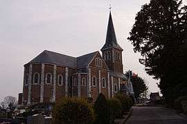 The church in Saint-Aubin-Routot | ||
| ||
 Saint-Aubin-Routot Location within Normandy region  Saint-Aubin-Routot | ||
| Coordinates: 49°31′26″N 0°19′36″E / 49.5239°N 0.3267°ECoordinates: 49°31′26″N 0°19′36″E / 49.5239°N 0.3267°E | ||
| Country | France | |
| Region | Normandy | |
| Department | Seine-Maritime | |
| Arrondissement | Le Havre | |
| Canton | Saint-Romain-de-Colbosc | |
| Area1 | 6.63 km2 (2.56 sq mi) | |
| Population (2006)2 | 1,287 | |
| • Density | 190/km2 (500/sq mi) | |
| Time zone | UTC+1 (CET) | |
| • Summer (DST) | UTC+2 (CEST) | |
| INSEE/Postal code | 76563 /76430 | |
| Elevation |
19–122 m (62–400 ft) (avg. 110 m or 360 ft) | |
|
1 French Land Register data, which excludes lakes, ponds, glaciers > 1 km2 (0.386 sq mi or 247 acres) and river estuaries. 2 Population without double counting: residents of multiple communes (e.g., students and military personnel) only counted once. | ||
Saint-Aubin-Routot is a commune in the Seine-Maritime department in the Normandy region in northern France.
Geography
A farming village in the Pays de Caux, situated some 12 miles (19 km) east of Le Havre, on the D01515 road, in the valley of the Bolbec river.
Heraldry
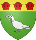 |
The arms of Saint-Aubin-Routot are blazoned : Vert, a dove holding in its beak an olive branch argent, and on a chief Or, 3 roses gules. |
Population
| 1962 | 1968 | 1975 | 1982 | 1990 | 1999 | 2006 |
|---|---|---|---|---|---|---|
| 645 | 646 | 941 | 1015 | 1077 | 1118 | 1287 |
| Starting in 1962: Population without duplicates | ||||||
Places of interest
- The church of St.Aubin, dating from the nineteenth century.
- The 700-year-old yewtree by the church.
See also
References
External links
| Wikimedia Commons has media related to Saint-Aubin-Routot. |
- Saint-Aubin-Routot on the Quid website (in French)
This article is issued from
Wikipedia.
The text is licensed under Creative Commons - Attribution - Sharealike.
Additional terms may apply for the media files.