Valliquerville
| Valliquerville | ||
|---|---|---|
| Commune | ||
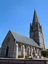 The church in Valliquerville | ||
| ||
 Valliquerville Location within Normandy region  Valliquerville | ||
| Coordinates: 49°36′52″N 0°41′25″E / 49.6144°N 0.6903°ECoordinates: 49°36′52″N 0°41′25″E / 49.6144°N 0.6903°E | ||
| Country | France | |
| Region | Normandy | |
| Department | Seine-Maritime | |
| Arrondissement | Rouen | |
| Canton | Yvetot | |
| Government | ||
| • Mayor | Jacques Cahard | |
| Area1 | 13.39 km2 (5.17 sq mi) | |
| Population (2006)2 | 1,297 | |
| • Density | 97/km2 (250/sq mi) | |
| Time zone | UTC+1 (CET) | |
| • Summer (DST) | UTC+2 (CEST) | |
| INSEE/Postal code | 76718 /76190 | |
| Elevation |
117–151 m (384–495 ft) (avg. 120 m or 390 ft) | |
|
1 French Land Register data, which excludes lakes, ponds, glaciers > 1 km2 (0.386 sq mi or 247 acres) and river estuaries. 2 Population without double counting: residents of multiple communes (e.g., students and military personnel) only counted once. | ||
Valliquerville is a commune in the Seine-Maritime department in the Normandy region in northern France.
Geography
A farming village situated in the Pays de Caux, some 25 miles (40 km) northwest of Rouen at the junction of the D6015 with the D131e and the D110 roads.
Heraldry
 |
The arms of the commune of Valliquerville are blazoned : Per pale highly indented argent and gules impaled with Vert, the local bell-tower argent issuant from base. |
Population
| Year | 1962 | 1968 | 1975 | 1982 | 1990 | 1999 | 2006 |
|---|---|---|---|---|---|---|---|
| Population | 720 | 769 | 870 | 980 | 1125 | 1164 | 1297 |
| From the year 1962 on: No double counting—residents of multiple communes (e.g. students and military personnel) are counted only once. | |||||||
Places of interest
- The church of Notre-Dame, dating from the thirteenth century.
See also
References
External links
| Wikimedia Commons has media related to Valliquerville. |
- Valliquerville on the Quid website (in French)
This article is issued from
Wikipedia.
The text is licensed under Creative Commons - Attribution - Sharealike.
Additional terms may apply for the media files.