Quevillon
| Quevillon | |
|---|---|
| Commune | |
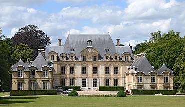 The chateau of la Riviere Bourdet | |
 Quevillon Location within Normandy region  Quevillon | |
| Coordinates: 49°25′12″N 0°57′15″E / 49.42°N 0.9542°ECoordinates: 49°25′12″N 0°57′15″E / 49.42°N 0.9542°E | |
| Country | France |
| Region | Normandy |
| Department | Seine-Maritime |
| Arrondissement | Rouen |
| Canton | Barentin |
| Intercommunality | Métropole Rouen Normandie |
| Government | |
| • Mayor | Jean-Pierre Petit |
| Area1 | 11.23 km2 (4.34 sq mi) |
| Population (2006)2 | 628 |
| • Density | 56/km2 (140/sq mi) |
| Time zone | UTC+1 (CET) |
| • Summer (DST) | UTC+2 (CEST) |
| INSEE/Postal code | 76513 /76840 |
| Elevation |
2–118 m (6.6–387.1 ft) (avg. 5 m or 16 ft) |
|
1 French Land Register data, which excludes lakes, ponds, glaciers > 1 km2 (0.386 sq mi or 247 acres) and river estuaries. 2 Population without double counting: residents of multiple communes (e.g., students and military personnel) only counted once. | |
Quevillon is a commune in the Seine-Maritime department in the Normandy region in northern France.
Geography
A forestry and farming village situated in a meander of the river Seine, some 5 miles (8.0 km) west of Rouen at the junction of the D67 and the D267 roads.
Population
| 1962 | 1968 | 1975 | 1982 | 1990 | 1999 | 2006 |
|---|---|---|---|---|---|---|
| 312 | 329 | 436 | 506 | 523 | 533 | 628 |
| Starting in 1962: Population without duplicates | ||||||
Places of interest
- The church of St.Martin, dating from the nineteenth century.
- The chapel of Saint-Jean, dating from the seventeenth century.
- The seventeenth century Château de La Rivière-Bourdet, with the chapel of Saint-Clotilde and a dovecote.
- A stone cross in the cemetery, erected in 1600.
See also
References
External links
| Wikimedia Commons has media related to Quevillon. |
- Quevillon on the Quid website (in French)
This article is issued from
Wikipedia.
The text is licensed under Creative Commons - Attribution - Sharealike.
Additional terms may apply for the media files.