La Bouille
| La Bouille | ||
|---|---|---|
| Commune | ||
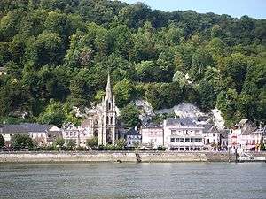 A general view of La Bouille | ||
| ||
 La Bouille Location within Normandy region  La Bouille | ||
| Coordinates: 49°21′04″N 0°55′55″E / 49.351°N 0.932°ECoordinates: 49°21′04″N 0°55′55″E / 49.351°N 0.932°E | ||
| Country | France | |
| Region | Normandy | |
| Department | Seine-Maritime | |
| Arrondissement | Rouen | |
| Canton | Elbeuf | |
| Intercommunality | Métropole Rouen Normandie | |
| Government | ||
| • Mayor (2014–2020) | Joel Temperton | |
| Area1 | 1.27 km2 (0.49 sq mi) | |
| Population (2014)2 | 764 | |
| • Density | 600/km2 (1,600/sq mi) | |
| Time zone | UTC+1 (CET) | |
| • Summer (DST) | UTC+2 (CEST) | |
| INSEE/Postal code | 76131 /76530 | |
| Elevation |
2–133 m (6.6–436.4 ft) (avg. 5 m or 16 ft) | |
|
1 French Land Register data, which excludes lakes, ponds, glaciers > 1 km2 (0.386 sq mi or 247 acres) and river estuaries. 2 Population without double counting: residents of multiple communes (e.g., students and military personnel) only counted once. | ||
.svg.png)
La Bouille is a commune in the Seine-Maritime department in the Normandy region in north-western France.
Geography
A small village (in area) surrounded by woodland situated south of a meander of the river Seine, some 11 miles (18 km) southwest of Rouen, at the junction of the D 64, D 132 and the D 675 roads. A ferry service crosses the river to Sahurs.
Population
| Historical population | ||
|---|---|---|
| Year | Pop. | ±% |
| 1793 | 959 | — |
| 1800 | 802 | −16.4% |
| 1806 | 877 | +9.4% |
| 1821 | 1,182 | +34.8% |
| 1831 | 1,171 | −0.9% |
| 1836 | 796 | −32.0% |
| 1841 | 772 | −3.0% |
| 1846 | 741 | −4.0% |
| 1851 | 745 | +0.5% |
| 1856 | 667 | −10.5% |
| 1861 | 652 | −2.2% |
| 1866 | 625 | −4.1% |
| 1872 | 602 | −3.7% |
| 1876 | 556 | −7.6% |
| 1881 | 562 | +1.1% |
| 1886 | 565 | +0.5% |
| 1891 | 544 | −3.7% |
| 1896 | 536 | −1.5% |
| 1901 | 515 | −3.9% |
| 1906 | 519 | +0.8% |
| 1911 | 502 | −3.3% |
| 1921 | 435 | −13.3% |
| 1926 | 466 | +7.1% |
| 1931 | 444 | −4.7% |
| 1936 | 497 | +11.9% |
| 1946 | 611 | +22.9% |
| 1954 | 618 | +1.1% |
| 1962 | 661 | +7.0% |
| 1968 | 611 | −7.6% |
| 1975 | 661 | +8.2% |
| 1982 | 550 | −16.8% |
| 1990 | 862 | +56.7% |
| 1999 | 791 | −8.2% |
| 2005 | 808 | +2.1% |
| 2006 | 805 | −0.4% |
| 2007 | 805 | +0.0% |
| 2008 | 797 | −1.0% |
| 2009 | 788 | −1.1% |
| 2010 | 780 | −1.0% |
| 2011 | 771 | −1.2% |
| 2012 | 793 | +2.9% |
| 2013 | 778 | −1.9% |
| 2014 | 764 | −1.8% |
Notable people
- Writer Hector Malot was born here in 1830.
- French actor Albert Lambert.
- La Bouille has been the subject of landscapes by Turner, Gauguin, Albert Lebourg, Robert Antoine Pinchon and Henri Vignet.
Places of interest

La Bouille and the ferry

The ferry dock at La Bouille
- The church of Sainte-Madeleine, dating from the sixteenth century.
- A sixteenth century salt warehouse.
- Several lesser buildings dating from the thirteenth century.
- The Château Albert Lambert.
- The seventeenth-century château de l'Ermitage
See also
References
External links
| Wikimedia Commons has media related to La Bouille. |
- La Bouille on the Quid website (in French)
This article is issued from
Wikipedia.
The text is licensed under Creative Commons - Attribution - Sharealike.
Additional terms may apply for the media files.