Rouxmesnil-Bouteilles
| Rouxmesnil-Bouteilles | |
|---|---|
| Commune | |
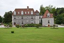 The town hall in Rouxmesnil-Bouteilles | |
 Rouxmesnil-Bouteilles Location within Normandy region  Rouxmesnil-Bouteilles | |
| Coordinates: 49°54′21″N 1°05′28″E / 49.9058°N 1.0911°ECoordinates: 49°54′21″N 1°05′28″E / 49.9058°N 1.0911°E | |
| Country | France |
| Region | Normandy |
| Department | Seine-Maritime |
| Arrondissement | Dieppe |
| Canton | Dieppe-1 |
| Intercommunality | CA Région Dieppoise |
| Government | |
| • Mayor (2008–2014) | Jean-Claude Grout |
| Area1 | 5.62 km2 (2.17 sq mi) |
| Population (2006)2 | 1,890 |
| • Density | 340/km2 (870/sq mi) |
| Time zone | UTC+1 (CET) |
| • Summer (DST) | UTC+2 (CEST) |
| INSEE/Postal code | 76545 /76370 |
| Elevation |
1–99 m (3.3–324.8 ft) (avg. 685 m or 2,247 ft) |
|
1 French Land Register data, which excludes lakes, ponds, glaciers > 1 km2 (0.386 sq mi or 247 acres) and river estuaries. 2 Population without double counting: residents of multiple communes (e.g., students and military personnel) only counted once. | |
Rouxmesnil-Bouteilles is a commune in the Seine-Maritime department in the Normandy region in northern France.
Geography
A small ex-farming town but now mostly involved with light industry, situated by the banks of the Arques River in the Pays de Caux at the junction of the D154 and the D154e roads, immediately south of Dieppe.
Population
| 1962 | 1968 | 1975 | 1982 | 1990 | 1999 | 2006 |
|---|---|---|---|---|---|---|
| 783 | 868 | 1005 | 1129 | 1686 | 1774 | 1890 |
| Starting in 1962: Population without duplicates | ||||||
Places of interest
- A sixteenth century priory.
- A sixteenth century manorhouse, once the mairie.
See also
References
External links
| Wikimedia Commons has media related to Rouxmesnil-Bouteilles. |
- Rouxmesnil-Bouteilles on the Quid website (in French)
This article is issued from
Wikipedia.
The text is licensed under Creative Commons - Attribution - Sharealike.
Additional terms may apply for the media files.