Ancretteville-sur-Mer
| Ancretteville-sur-Mer | |
|---|---|
| Commune | |
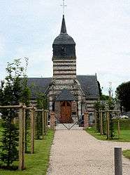 The church in Ancretteville-sur-Mer | |
 Ancretteville-sur-Mer Location within Normandy region  Ancretteville-sur-Mer | |
| Coordinates: 49°47′21″N 0°30′44″E / 49.7892°N 0.5122°ECoordinates: 49°47′21″N 0°30′44″E / 49.7892°N 0.5122°E | |
| Country | France |
| Region | Normandy |
| Department | Seine-Maritime |
| Arrondissement | Le Havre |
| Canton | Fécamp |
| Intercommunality | Fécamp Caux Littoral |
| Government | |
| • Mayor (2014-2020) | Jean-Louis Panel |
| Area1 | 3.15 km2 (1.22 sq mi) |
| Population (2014)2 | 184 |
| • Density | 58/km2 (150/sq mi) |
| Time zone | UTC+1 (CET) |
| • Summer (DST) | UTC+2 (CEST) |
| INSEE/Postal code | 76011 /76540 |
| Elevation |
49–108 m (161–354 ft) (avg. 98 m or 322 ft) |
|
1 French Land Register data, which excludes lakes, ponds, glaciers > 1 km2 (0.386 sq mi or 247 acres) and river estuaries. 2 Population without double counting: residents of multiple communes (e.g., students and military personnel) only counted once. | |
Ancretteville-sur-Mer is a commune in the Seine-Maritime department in the Normandy region in northern France.
Geography
A small farming village situated some 32 miles (51 km) northeast of Le Havre, at the junction of the D33 and the D68.
Population
| Year | 1962 | 1968 | 1975 | 1982 | 1990 | 1999 | 2006 |
|---|---|---|---|---|---|---|---|
| Population | 188 | 209 | 162 | 178 | 183 | 178 | 185 |
| From the year 1962 on: No double counting—residents of multiple communes (e.g. students and military personnel) are counted only once. | |||||||
Places of interest
- The church of Saint-Amand, dating from the twelfth century
- The eighteenth century Château d'Angerval.
See also
References
External links
| Wikimedia Commons has media related to Ancretteville-sur-Mer. |
- Ancretteville-sur-Mer on the Quid website (in French)
This article is issued from
Wikipedia.
The text is licensed under Creative Commons - Attribution - Sharealike.
Additional terms may apply for the media files.