Touffreville-la-Corbeline
| Touffreville-la-Corbeline | ||
|---|---|---|
| Commune | ||
| ||
 Touffreville-la-Corbeline Location within Normandy region  Touffreville-la-Corbeline | ||
| Coordinates: 49°34′54″N 0°45′51″E / 49.5817°N 0.7642°ECoordinates: 49°34′54″N 0°45′51″E / 49.5817°N 0.7642°E | ||
| Country | France | |
| Region | Normandy | |
| Department | Seine-Maritime | |
| Arrondissement | Rouen | |
| Canton | Yvetot | |
| Government | ||
| • Mayor | Micheline Vincent | |
| Area1 | 12.59 km2 (4.86 sq mi) | |
| Population (2006)2 | 798 | |
| • Density | 63/km2 (160/sq mi) | |
| Time zone | UTC+1 (CET) | |
| • Summer (DST) | UTC+2 (CEST) | |
| INSEE/Postal code | 76702 /76190 | |
| Elevation |
29–142 m (95–466 ft) (avg. 145 m or 476 ft) | |
|
1 French Land Register data, which excludes lakes, ponds, glaciers > 1 km2 (0.386 sq mi or 247 acres) and river estuaries. 2 Population without double counting: residents of multiple communes (e.g., students and military personnel) only counted once. | ||
Touffreville-la-Corbeline is a commune in the Seine-Maritime department in the Normandy region in northern France.
Geography
A farming village situated in the Pays de Caux, some 22 miles (35 km) northwest of Rouen at the junction of the D104, D37 and the D131 roads.
Heraldry
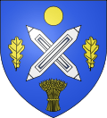 |
The arms of Touffreville-la-Corbeline are blazoned : Azure, 2 weavers shuttles in saltire argent between a bezant, 2 oak leaves and a garb [of wheat] Or. |
Population
| 1962 | 1968 | 1975 | 1982 | 1990 | 1999 | 2006 |
|---|---|---|---|---|---|---|
| 564 | 586 | 614 | 664 | 789 | 804 | 798 |
| Starting in 1962: Population without duplicates | ||||||
Places of interest
See also
References
External links
| Wikimedia Commons has media related to Touffreville-la-Corbeline. |
- Touffreville-la-Corbeline on the Quid website (in French)
This article is issued from
Wikipedia.
The text is licensed under Creative Commons - Attribution - Sharealike.
Additional terms may apply for the media files.