Normanville, Seine-Maritime
| Normanville | ||
|---|---|---|
| Commune | ||
| ||
 Normanville Location within Normandy region  Normanville | ||
| Coordinates: 49°41′44″N 0°35′42″E / 49.6956°N 0.595°ECoordinates: 49°41′44″N 0°35′42″E / 49.6956°N 0.595°E | ||
| Country | France | |
| Region | Normandy | |
| Department | Seine-Maritime | |
| Arrondissement | Dieppe | |
| Canton | Saint-Valery-en-Caux | |
| Intercommunality | CC Côte d'Albâtre | |
| Area1 | 9.35 km2 (3.61 sq mi) | |
| Population (2009)2 | 582 | |
| • Density | 62/km2 (160/sq mi) | |
| Time zone | UTC+1 (CET) | |
| • Summer (DST) | UTC+2 (CEST) | |
| INSEE/Postal code | 76470 /76640 | |
| Elevation |
93–139 m (305–456 ft) (avg. 130 m or 430 ft) | |
|
1 French Land Register data, which excludes lakes, ponds, glaciers > 1 km2 (0.386 sq mi or 247 acres) and river estuaries. 2 Population without double counting: residents of multiple communes (e.g., students and military personnel) only counted once. | ||
Normanville is a commune in the Seine-Maritime department in the Normandy region in north-western France.
Geography
A farming village in the Pays de Caux, situated some 28 miles (45 km) northeast of Le Havre, at the junction of the D50 and D33 roads.
Heraldry
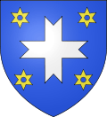 |
The arms of Normanville are blazoned : Azure, a cross fourchée argent between 4 mullets of 6 points voided Or. (a cross fourchée in English heraldry would have the points splayed out more, but the French and English terms seem to be considered equivalent.) |
Population
| 1962 | 1968 | 1975 | 1982 | 1990 | 1999 | 2006 | 2009 |
|---|---|---|---|---|---|---|---|
| 423 | 448 | 422 | 423 | 530 | 589 | 579 | 582 |
| Starting from 1962: Population without duplicates | |||||||
Places of interest
- The church of Sts.Ouen et Barthélemy, dating from the thirteenth century.
- A fifteenth century manorhouse at Mesnil Lieubourg
In Literature
- In Moose: Chapters From My Life (the 2013, posthumously published autobiography of Academy Award winning songwriter, Robert B. Sherman) World War II Normanville provides the central backdrop to the author's narrative.
See also
References
External links
| Wikimedia Commons has media related to Normanville (Seine-Maritime). |
- Normanville on the Quid website (in French)
This article is issued from
Wikipedia.
The text is licensed under Creative Commons - Attribution - Sharealike.
Additional terms may apply for the media files.