Gommerville, Seine-Maritime
| Gommerville | ||
|---|---|---|
| Commune | ||
 The chateau of Filieres | ||
| ||
 Gommerville Location within Normandy region  Gommerville | ||
| Coordinates: 49°33′28″N 0°22′04″E / 49.5578°N 0.3678°ECoordinates: 49°33′28″N 0°22′04″E / 49.5578°N 0.3678°E | ||
| Country | France | |
| Region | Normandy | |
| Department | Seine-Maritime | |
| Arrondissement | Le Havre | |
| Canton | Saint-Romain-de-Colbosc | |
| Government | ||
| • Mayor (2001–2008) | Mr Ribet | |
| Area1 | 7.39 km2 (2.85 sq mi) | |
| Population (2006)2 | 719 | |
| • Density | 97/km2 (250/sq mi) | |
| Time zone | UTC+1 (CET) | |
| • Summer (DST) | UTC+2 (CEST) | |
| INSEE/Postal code | 76303 /76430 | |
| Elevation |
108–134 m (354–440 ft) (avg. 124 m or 407 ft) | |
|
1 French Land Register data, which excludes lakes, ponds, glaciers > 1 km2 (0.386 sq mi or 247 acres) and river estuaries. 2 Population without double counting: residents of multiple communes (e.g., students and military personnel) only counted once. | ||
Gommerville is a commune in the Seine-Maritime department in the Normandy region in northern France.
Geography
A farming village situated in the Pays de Caux, some 11 miles (18 km) northeast of Le Havre, at the junction of the D80 and D31 roads. Junction 6 of the A29 autoroute is within the boundary of the commune.
Heraldry
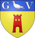 |
The arms of Gommerville are blazoned : Or, a tower gules opened and pierced of the field, on a chief azure, a dove descending between the capital letters G and V argent. |
Population
| Year | 1962 | 1968 | 1975 | 1982 | 1990 | 1999 | 2006 |
|---|---|---|---|---|---|---|---|
| Population | 436 | 522 | 540 | 602 | 604 | 648 | 719 |
| From the year 1962 on: No double counting—residents of multiple communes (e.g. students and military personnel) are counted only once. | |||||||
Places of interest
- The church of St.Martin, dating from the twelfth century.
- The remains of a feudal chateau.
- The Château de Filières (in French), open to the public.
- The chateau Joly.
- A sixteenth century manorhouse at Rebomare.
See also
References
External links
| Wikimedia Commons has media related to Gommerville (Seine-Maritime). |
- Gommerville on the Quid website (in French)
This article is issued from
Wikipedia.
The text is licensed under Creative Commons - Attribution - Sharealike.
Additional terms may apply for the media files.