Saint-Maurice-d'Ételan
| Saint-Maurice-d’Ételan | |
|---|---|
| Commune | |
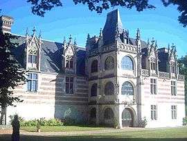 The chateau of Ételan | |
 Saint-Maurice-d’Ételan Location within Normandy region  Saint-Maurice-d’Ételan | |
| Coordinates: 49°27′36″N 0°36′47″E / 49.46°N 0.613°ECoordinates: 49°27′36″N 0°36′47″E / 49.46°N 0.613°E | |
| Country | France |
| Region | Normandy |
| Department | Seine-Maritime |
| Arrondissement | Le Havre |
| Canton | Notre-Dame-de-Gravenchon |
| Intercommunality | CA Caux vallée de Seine |
| Government | |
| • Mayor (2008–2013) | Franck de Belloy |
| Area1 | 14.24 km2 (5.50 sq mi) |
| Population (2006)2 | 334 |
| • Density | 23/km2 (61/sq mi) |
| Time zone | UTC+1 (CET) |
| • Summer (DST) | UTC+2 (CEST) |
| INSEE/Postal code | 76622 /76330 |
| Elevation |
3–121 m (9.8–397.0 ft) (avg. 20 m or 66 ft) |
|
1 French Land Register data, which excludes lakes, ponds, glaciers > 1 km2 (0.386 sq mi or 247 acres) and river estuaries. 2 Population without double counting: residents of multiple communes (e.g., students and military personnel) only counted once. | |
Saint-Maurice-d’Ételan is a commune in the Seine-Maritime department in the Normandy region in northern France.
Geography
A farming village in the Pays de Caux, situated some 21 miles (34 km) east of Le Havre, on the D81 and D281 roads, by the banks of the meandering river Seine, which forms the commune’s southern border.
Population
| Year | 1962 | 1968 | 1975 | 1982 | 1990 | 1999 | 2006 |
|---|---|---|---|---|---|---|---|
| Population | 241 | 255 | 243 | 230 | 211 | 239 | 334 |
| From the year 1962 on: No double counting—residents of multiple communes (e.g. students and military personnel) are counted only once. | |||||||
Places of interest
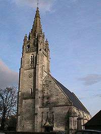
The church
- The church of St. Maurice, dating from the fifteenth century.
- The fourteenth-century chateau.
People

Félix Faure - 7th President of France
- Félix Faure (1841–1899), 7th president of France
- André Bettencourt (1919–2007), government minister
- Ernest Picard-Destelan (in French), French navy officer
- Laurence de Cambronne (1951–), editor in chief of the magazine Elle
See also
References
External links
| Wikimedia Commons has media related to Saint-Maurice-d'Ételan. |
- Saint-Maurice-d’Ételan on the Quid website (in French)
This article is issued from
Wikipedia.
The text is licensed under Creative Commons - Attribution - Sharealike.
Additional terms may apply for the media files.