Bois-l'Évêque
| Bois-l’Évêque | ||
|---|---|---|
| Commune | ||
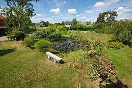 The pond in Bois-l’Évêque | ||
| ||
 Bois-l’Évêque Location within Normandy region  Bois-l’Évêque | ||
| Coordinates: 49°27′01″N 1°15′55″E / 49.4503°N 1.2653°ECoordinates: 49°27′01″N 1°15′55″E / 49.4503°N 1.2653°E | ||
| Country | France | |
| Region | Normandy | |
| Department | Seine-Maritime | |
| Arrondissement | Rouen | |
| Canton | Le Mesnil-Esnard | |
| Government | ||
| • Mayor | Frédéric Tihi | |
| Area1 | 7.21 km2 (2.78 sq mi) | |
| Population (2006)2 | 508 | |
| • Density | 70/km2 (180/sq mi) | |
| Time zone | UTC+1 (CET) | |
| • Summer (DST) | UTC+2 (CEST) | |
| INSEE/Postal code | 76111 /76160 | |
| Elevation |
100–163 m (328–535 ft) (avg. 145 m or 476 ft) | |
|
1 French Land Register data, which excludes lakes, ponds, glaciers > 1 km2 (0.386 sq mi or 247 acres) and river estuaries. 2 Population without double counting: residents of multiple communes (e.g., students and military personnel) only counted once. | ||
.svg.png)
Bois-l’Évêque is a commune in the Seine-Maritime department in the Normandy region in northern France.
Geography
A farming village situated some 8 miles (13 km) east of Rouen at the junction of the D53 and the D43 roads.
Population
| Year | 1962 | 1968 | 1975 | 1982 | 1990 | 1999 | 2006 |
|---|---|---|---|---|---|---|---|
| Population | 161 | 175 | 202 | 260 | 290 | 368 | 508 |
| From the year 1962 on: No double counting—residents of multiple communes (e.g. students and military personnel) are counted only once. | |||||||
Places of interest
- The church of Notre-Dame, dating from the nineteenth century.
- Remnants of the 13th-century priory de Beaulieu.
- The nineteenth century Château de Bethel.
- Ruins of a 13th-century chapel.
See also
References
External links
| Wikimedia Commons has media related to Bois-l'Évêque. |
- Bois-l’Évêque on the Quid website (in French)
This article is issued from
Wikipedia.
The text is licensed under Creative Commons - Attribution - Sharealike.
Additional terms may apply for the media files.