Saâne
| Saâne | |
|---|---|
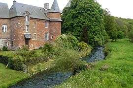 The Saâne river (Biville-la-Rivière) | |
| Native name | La Saâne |
| Country | France |
| Physical characteristics | |
| Main source |
Val-de-Saâne 158 m (518 ft) |
| River mouth |
English Channel 49°53′N 0°55′E / 49.883°N 0.917°ECoordinates: 49°53′N 0°55′E / 49.883°N 0.917°E |
| Length | 40.1 km (24.9 mi) |
| Discharge |
|
| Basin features | |
| Basin size | 270 km2 (100 sq mi) |
The Saâne is a river of Normandy, France, 40 kilometres (25 mi) in length,[1] flowing through the department of Seine-Maritime.
Geography
The Saâne has its source in the Pays de Caux in the territory of the hamlet of Varvannes, in the commune of Val-de-Saâne. Taking a northward journey, it flows through the communes of Saâne-Saint-Just, Auzouville-sur-Saâne, Biville-la-Rivière, Brachy, Gueures, Ouville-la-Rivière and Longueil and meets the English Channel between Quiberville and Sainte-Marguerite-sur-Mer. At Longueil, not far from the mouth, the flow is relatively low, at 2.6 m/s, because of the small size of the watershed (270 km),[2] however, at Gueures, on the right bank, a significant tributary, the Vienne river, 15 km in length, joins with the Saane. Like most other rivers in the region, the Saâne is classified as a first class river, offering anglers the chance to catch trout and salmon.[3]
Bibliography
- Albert Hennetier, Aux sources normandes: Promenade au fil des rivières en Seine-Maritime, Ed. Bertout, Luneray, 2006 ISBN 2867436230
See also
External links
- Accès aux villes et villages de France du Quid (in French)
- French Geography website (in French)
References
- ↑ Sandre. "Fiche cours d'eau - Saâne (G4--0200)".
- ↑ Station hydrologique de Longueil. Données hydrologiques, code de la station : G4202010. Consulted 11 June 2008.
- ↑ The Saane The Saane on the Natura 2000 website.
- This article is based on the equivalent article from the French Wikipedia, consulted on October 15th 2008.