Rémy
Rémy is a commune in the department of Pas-de-Calais in the Hauts-de-France region of France.
For the saint called "Saint Rémi" or "Saint Rémy" in French, see Saint Remigius. For the name, see Remy (name). For other uses, see Remy (disambiguation).
Rémy | |
|---|---|
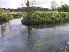 The Sensée | |
 Coat of arms | |
Location of Rémy 
| |
 Rémy  Rémy | |
| Coordinates: 50°15′16″N 2°57′24″E | |
| Country | France |
| Region | Hauts-de-France |
| Department | Pas-de-Calais |
| Arrondissement | Arras |
| Canton | Brebières |
| Intercommunality | CC Osartis Marquion |
| Government | |
| • Mayor (2008–2014) | Annick Danel |
| Area 1 | 3.59 km2 (1.39 sq mi) |
| Population (2017-01-01)[1] | 395 |
| • Density | 110/km2 (280/sq mi) |
| Time zone | UTC+01:00 (CET) |
| • Summer (DST) | UTC+02:00 (CEST) |
| INSEE/Postal code | 62703 /62156 |
| Elevation | 42–71 m (138–233 ft) (avg. 45 m or 148 ft) |
| 1 French Land Register data, which excludes lakes, ponds, glaciers > 1 km2 (0.386 sq mi or 247 acres) and river estuaries. | |
Geography
Rémy lies in the valley of the Sensée river, some 10 miles (16 km) southeast of Arras, on the D9 road.
Population
| 1962 | 1968 | 1975 | 1982 | 1990 | 1999 | 2006 |
|---|---|---|---|---|---|---|
| 126 | 151 | 178 | 213 | 254 | 265 | 253 |
| Census count starting from 1962: Population without duplicates | ||||||
Places of interest
External links
| Wikimedia Commons has media related to Rémy (Pas-de-Calais). |
- Rémy on the Quid website (in French)
| Authority control |
|
|---|
This article is issued from Wikipedia. The text is licensed under Creative Commons - Attribution - Sharealike. Additional terms may apply for the media files.