Monchel-sur-Canche
Monchel-sur-Canche is a commune in the Pas-de-Calais department in the Hauts-de-France region of France.
Monchel-sur-Canche | |
|---|---|
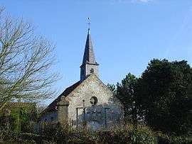 The church of Monchel-sur-Canche | |
 Coat of arms | |
Location of Monchel-sur-Canche 
| |
 Monchel-sur-Canche  Monchel-sur-Canche | |
| Coordinates: 50°18′13″N 2°12′33″E | |
| Country | France |
| Region | Hauts-de-France |
| Department | Pas-de-Calais |
| Arrondissement | Arras |
| Canton | Saint-Pol-sur-Ternoise |
| Intercommunality | CC Ternois |
| Government | |
| • Mayor (2008–2014) | Bertrand Cléret |
| Area 1 | 5.06 km2 (1.95 sq mi) |
| Population (2017-01-01)[1] | 90 |
| • Density | 18/km2 (46/sq mi) |
| Time zone | UTC+01:00 (CET) |
| • Summer (DST) | UTC+02:00 (CEST) |
| INSEE/Postal code | 62577 /62270 |
| Elevation | 52–133 m (171–436 ft) (avg. 120 m or 390 ft) |
| 1 French Land Register data, which excludes lakes, ponds, glaciers > 1 km2 (0.386 sq mi or 247 acres) and river estuaries. | |
Geography
Monchel-sur-Canche is situated on the banks and in the valley of the river Canche, which feeds the local fish/trout farm, it is 25 miles (40 km) west of Arras, on the D102 road.
Population
| 1962 | 1968 | 1975 | 1982 | 1990 | 1999 | 2006 |
|---|---|---|---|---|---|---|
| 62 | 68 | 67 | 67 | 66 | 71 | 63 |
| Census count starting from 1962: Population without duplicates | ||||||
Places of interest
- The fifteenth century church of "St Juste", who is the patron saint of farmers.
References
- "Populations légales 2017". INSEE. Retrieved 6 January 2020.
| Wikimedia Commons has media related to Monchel-sur-Canche. |
| Authority control |
|
|---|
This article is issued from Wikipedia. The text is licensed under Creative Commons - Attribution - Sharealike. Additional terms may apply for the media files.