Dennebrœucq
Dennebrœucq is a commune in the Pas-de-Calais department in the Hauts-de-France region of France. The medieval Flemish placename used to be Denebroek[2]
Dennebrœucq | |
|---|---|
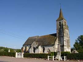 The church of Dennebrœucq | |
 Coat of arms | |
Location of Dennebrœucq 
| |
 Dennebrœucq  Dennebrœucq | |
| Coordinates: 50°34′27″N 2°09′14″E | |
| Country | France |
| Region | Hauts-de-France |
| Department | Pas-de-Calais |
| Arrondissement | Saint-Omer |
| Canton | Fruges |
| Intercommunality | Pays de Saint-Omer |
| Government | |
| • Mayor | Marcel Lapouille |
| Area 1 | 3.73 km2 (1.44 sq mi) |
| Population (2017-01-01)[1] | 389 |
| • Density | 100/km2 (270/sq mi) |
| Time zone | UTC+01:00 (CET) |
| • Summer (DST) | UTC+02:00 (CEST) |
| INSEE/Postal code | 62267 /62560 |
| Elevation | 53–140 m (174–459 ft) (avg. 70 m or 230 ft) |
| 1 French Land Register data, which excludes lakes, ponds, glaciers > 1 km2 (0.386 sq mi or 247 acres) and river estuaries. | |
Geography
The village spreads along the D159 road, 12 miles (19 km) south of Saint-Omer.
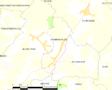
Map of the commune and adjacent places
History
Dennebrœucq is home to the adventure playground Dennlys Parc, created in 1983 on the site of the old watermill.
Population
| Year | 1962 | 1968 | 1975 | 1982 | 1990 | 1999 |
|---|---|---|---|---|---|---|
| Population | 263 | 279 | 257 | 269 | 310 | 314 |
| From the year 1962 on: No double counting—residents of multiple communes (e.g. students and military personnel) are counted only once. | ||||||
Places of interest
- The church of St.Leger, dating from the sixteenth century.
- The nineteenth century chapel.
References
- "Populations légales 2017". INSEE. Retrieved 6 January 2020.
- Dennebrœucq/Denebroek: proussel.voila.net Archived 2015-07-05 at the Wayback Machine
This article is issued from Wikipedia. The text is licensed under Creative Commons - Attribution - Sharealike. Additional terms may apply for the media files.