Bomy
Bomy is a commune in the Pas-de-Calais department in the Hauts-de-France region in northern France.
Bomy | |
|---|---|
 A typical building of Pas-de-Calais, in Bomy | |
 Coat of arms | |
Location of Bomy 
| |
 Bomy  Bomy | |
| Coordinates: 50°34′29″N 2°14′10″E | |
| Country | France |
| Region | Hauts-de-France |
| Department | Pas-de-Calais |
| Arrondissement | Saint-Omer |
| Canton | Fruges |
| Intercommunality | Pays de Saint-Omer |
| Government | |
| • Mayor (2008–2014) | Alain Deblock |
| Area 1 | 14.63 km2 (5.65 sq mi) |
| Population (2017-01-01)[1] | 631 |
| • Density | 43/km2 (110/sq mi) |
| Time zone | UTC+01:00 (CET) |
| • Summer (DST) | UTC+02:00 (CEST) |
| INSEE/Postal code | 62153 /62960 |
| Elevation | 85–180 m (279–591 ft) (avg. 102 m or 335 ft) |
| 1 French Land Register data, which excludes lakes, ponds, glaciers > 1 km2 (0.386 sq mi or 247 acres) and river estuaries. | |
It's surrounded by the common Beaumetz-lès-Aire, Erny-Saint-Julien and Laires, Bomy is located 19 km southwest of Saint-Omer's largest city.
Geography
A village situated 12 miles (19 km) south of Saint-Omer, on the D130 road.
It's surrounded by the common Beaumetz-lès-Aire, Erny-Saint-Julien and Laires, Bomy is located 19 km southwest of Saint-Omer, the largest city around.[2]
Population
| Historical population | ||
|---|---|---|
| Year | Pop. | ±% |
| 1962 | 653 | — |
| 1968 | 674 | +3.2% |
| 1975 | 658 | −2.4% |
| 1982 | 603 | −8.4% |
| 1990 | 608 | +0.8% |
| 1999 | 604 | −0.7% |
| 2009 | 596 | −1.3% |
Sights
- The church of St. Vaast, dating from the thirteenth century.
- The remains of the old château, where a truce between France and Spain was signed in 1537.
- The present-day château. The building dates from 1755. It was confiscated during the French Revolution and sold for use as a sugar beet factory. It was sold again in 1839 to the Baron de Vilmarest.
 The wooded site of the old château
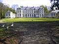 The main façade of the present building
 View of the rear of the château
 Weir on the river Locquette
References
- "Populations légales 2017". INSEE. Retrieved 6 January 2020.
- "Annuaire-Mairie"
| Wikimedia Commons has media related to Bomy. |
| Authority control |
|
|---|
This article is issued from Wikipedia. The text is licensed under Creative Commons - Attribution - Sharealike. Additional terms may apply for the media files.