Lefaux
Lefaux is a commune in the Pas-de-Calais department in the Hauts-de-France region of France.
Lefaux | |
|---|---|
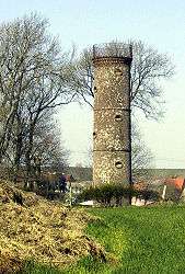 Semaphore tower | |
 Coat of arms | |
Location of Lefaux 
| |
 Lefaux  Lefaux | |
| Coordinates: 50°32′37″N 1°39′38″E | |
| Country | France |
| Region | Hauts-de-France |
| Department | Pas-de-Calais |
| Arrondissement | Montreuil |
| Canton | Étaples |
| Intercommunality | CA Deux Baies en Montreuillois |
| Government | |
| • Mayor | Geneviève Margueritte |
| Area 1 | 8.25 km2 (3.19 sq mi) |
| Population (2017-01-01)[1] | 238 |
| • Density | 29/km2 (75/sq mi) |
| Time zone | UTC+01:00 (CET) |
| • Summer (DST) | UTC+02:00 (CEST) |
| INSEE/Postal code | 62496 /62630 |
| Elevation | 23–152 m (75–499 ft) (avg. 75 m or 246 ft) |
| 1 French Land Register data, which excludes lakes, ponds, glaciers > 1 km2 (0.386 sq mi or 247 acres) and river estuaries. | |
Geography
Lefaux is situated 8 miles (16 km) north of Montreuil-sur-Mer on the D148 road.
Population
| Year | 1962 | 1968 | 1975 | 1982 | 1990 | 1999 | 2006 |
|---|---|---|---|---|---|---|---|
| Population | 188 | 199 | 198 | 203 | 204 | 242 | 240 |
| From the year 1962 on: No double counting—residents of multiple communes (e.g. students and military personnel) are counted only once. | |||||||
Places of interest
- The nineteenth century church of Saint-Jean-Baptiste
- The semaphore tower at Lefaux, a remnant of the first telegraphic system, created by Claude Chappe in 1793.
References
- "Populations légales 2017". INSEE. Retrieved 6 January 2020.
| Wikimedia Commons has media related to Lefaux. |
| Authority control |
|
|---|
This article is issued from Wikipedia. The text is licensed under Creative Commons - Attribution - Sharealike. Additional terms may apply for the media files.