Douriez
Douriez is a commune in the Pas-de-Calais department in the Hauts-de-France region of France.
Douriez | |
|---|---|
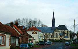 The centre of Douriez | |
 Coat of arms | |
Location of Douriez 
| |
 Douriez  Douriez | |
| Coordinates: 50°19′59″N 1°52′43″E | |
| Country | France |
| Region | Hauts-de-France |
| Department | Pas-de-Calais |
| Arrondissement | Montreuil |
| Canton | Auxi-le-Château |
| Intercommunality | CC Sept Vallées |
| Government | |
| • Mayor | Paul Becquet |
| Area 1 | 8.84 km2 (3.41 sq mi) |
| Population (2017-01-01)[1] | 326 |
| • Density | 37/km2 (96/sq mi) |
| Time zone | UTC+01:00 (CET) |
| • Summer (DST) | UTC+02:00 (CEST) |
| INSEE/Postal code | 62275 /62870 |
| Elevation | 7–102 m (23–335 ft) (avg. 14 m or 46 ft) |
| 1 French Land Register data, which excludes lakes, ponds, glaciers > 1 km2 (0.386 sq mi or 247 acres) and river estuaries. | |
Geography
A rural village situated some 30 miles (48 km) southeast of Montreuil-sur-Mer on the D119 road, by the banks of the river Authie, the border with the Somme department.
Places of interest
- The sixteenth-century church of the Nativité-de-Notre-Dame
- Remains of a 13th-century château
- A water mill
- Douriez Church
- Chateau Valloires
- Douries Chateau (Manoir)
- l'Estaminet Restaurant
- Douriez part and one of the seven valleys of nature
- Douriez the home of Baron & Baroness Guibal
- l'Auberge du gros tilleul (the best ***** )
Population
| Year | 1962 | 1968 | 1975 | 1982 | 1990 | 1999 |
|---|---|---|---|---|---|---|
| Population | 276 | 281 | 239 | 259 | 256 | 296 |
| From the year 1962 on: No double counting—residents of multiple communes (e.g. students and military personnel) are counted only once. | ||||||
References
- "Populations légales 2017". INSEE. Retrieved 6 January 2020.
| Wikimedia Commons has media related to Douriez. |
| Authority control |
|
|---|
This article is issued from Wikipedia. The text is licensed under Creative Commons - Attribution - Sharealike. Additional terms may apply for the media files.